Uxmal

Location and Access

The ruins of Uxmal lie some 15 km to the south-southeast of Muna, or about 80 km south of Merida. The terrain on which the ancient city was built is part of an extensive zone consisting largely of low hills sparsely covered with lithosol (tzekel) or rendzina (kaccab) soils, with bottom lands of fertile red clay soil (kancab), this in turn merging into the Iuvisols of season~ ally flooded land (akalche) (Dunning n.d., tables 1, 2 and fig. 12).

To the north this zone is sharply delimited by a range of hills, the Sierrita de Tieul or Cordon Puuc, which runs west-northwest to east-southeast, with Muna lying just across this range, close against its flank. Streams are not found in this zone, but a few ponds exist, and a number of aguadas, many of them perhaps man-made or at least artificially improved (Barrera Rubio 1987). Other sources of water for the inhabitants have been chultuns for the catchment and storage of rainwater, a few cenotes or subterranean aquifers accessible in deep caves, and in colonial times deep wells or norias through which water was raised using capstans powered by draft animals.

Until early in this century the usual route taken by visitors coming from Merida took them through Muna and then on to Hacienda Uxmal via San Jose Tipceh, thereby avoiding the steeper slopes of the Sierrita near Muna. From the hacienda the ruins lay less than 2 km further south. An alterna~ tive way from Merida passed through Maxcanu and Becal, reaching the ruins from the west. This route is shown on nineteenth century maps of the peninsula such as that of Joaquin Hiibbe and Andres Aznar Perez published in 1878.

The two routes probably united just north of the ruins. From this point the road went on past the Adivino or Temple of the Magician, along the foot of the great terrace of the Palace of the Governor, and then made its way south to Campeche via Bolonchen without making a detour through Santa Elena (then known as Nohcacab). In his general view of the palace (Stephens 1843, vol. 1, frontispiece) Frederick Catherwood captured a moment of heavy traffic in front of the palace, made up of horsemen, porters, two caches or litters, pack animals, and a hunter, all heading north.

The more direct route from Muna to the ruins, over the Sierrita, was first opened for the visit of the Empress Carlota, who was duly carried over it in a litter (Le Plongeon 1885, p. 376). In time this track was improved for the use of wheeled vehicles and eventually was transformed into Federal Highway 180, which runs close by the ruins on its way to Campeche via Hopelchen.

Map of Uxmal

Principal Investigations at the Site

Uxmal is one of the three great Maya cities-Chichen Itza and Copan being the others-of which we have descriptions dating from the sixteenth century, for in 1588 the Franciscan Padre Alonso Ponce paid a visit, an account of which, written by his secretary Antonio de Ciudad Real, has survived (Relacion Breve 1872, LVlll, pp. 455-461; English translation of the same passage given in Spinden 1975, pp. 5-8). Ciudad Real's description is astonishingly fuIl and accurate, with mention even of such details as cardholders and the construction of corbel vaults.

The first published illustrations of Uxmal, the work of Frederick Waldeck (1838), contributed little to knowledge of the ruins; they are fanciful and restored and were almost at once supplanted by the marvelous descriptions and illustrations of John Lloyd Stephens and Frederick Catherwood. This incomparable pair of travelers first visited Uxmal in 1840, returning two years later for a longer stay (Stephens 1841 and 1843).

On their first visit Stephens and Catherwood were fortunate in finding the ruins uncharacteristically clear of vegetation. The ruins, which lay within the boundaries of the hacienda, had recently been burnt over for the cultivation of maize, so they were able to observe and chart on their map the ruined waIl running from opposite the Adivino to the Vieja, now known to be a section of the possibly defensive muralIa-a feature that was to escape further attention for well over a century.

In the southwesternmost chamber of the palace they found a wooden lintel 10 feet (3.05 m) long, 23 inches (0.58 m) wide, and 12 inches (0.30 m) thick, by then fallen from its setting. "On the face was a line of characters carved or stamped, almost obliterated, but which we made out to be hieroglyphics and, so far as we could understand them, similar to those used at Copan and Palenque." On leaving from their second visit to Uxmal they took the lintel with them for display in Catherwood's Panorama, where unfortunately two years later it was consumed in a disastrous fire along with other items in their collection (Stephens 1843, vol. 1, pp. 178-179).

Uxmal had a very bad reputation for malaria; it was said that no child born on the hacienda ever survived to grow up there (Holmes 1895, p. 80). This danger and the lingering War of the Castes kept most visitors away for the next 40 years; but not all of them, for in 1860 Desire Charnay arrived and then managed, under most difficult conditions, to take a justly famous set of large-format photographs (Viollet-le-Duc and Charnay 1863).

Charnay was followed five years later by the Abbe Brasseur de Bourbourg, whose report (Brasseur de Bourbourg 1867) presents a site plan showing the Cementerio Group and one of its platforms; but the Abbe de voted so much of his time to detection of ancient but largely illusory works of hydraulic engineering that unfortunately he added almost nothing to the store of information already provided by Stephens and Catherwood.

After about 1880, however, members of the first generation of archaeologists-as distinct from antiquarians-began to visit, notably E. H. Thompson, Alfred Maudslay, Teobert Maler, William H. Holmes, Eduard SeIer, and Sylvanus G. Morley. One of the most valuable products of the years before the first World War was a work compiled by SeIer in the course of three visits between 1902 and 1911, Die Ruinen von Uxmal (SeIer 1917). By then, day visitors had also become so numerous that "the magnificent House of the Governor ... is now almost covered with names on the front and on the cement walls inside. These names are painted in black, blue, and red, and the letters are in some cases 12 inches high, and there are to be seen the names of men who are widely known in the scientific world" (Saville 1893, p. 91).

In 1909 the young Morley spent several days at Uxmal investigating and mapping the Palomas and South Quadrangle group (Morley 1910); in fact he was the first to describe the South Temple in print.

The year 1927 saw the beginning of the Mexican government's intermittent but still continuing program of restorations at Uxmal, for in that year the exterior of the Palace of the Governor was consolidated, with as many as possible of the fallen facade elements put back in place (Direcci6n de Arqueologia 1928).

Three years later an expedition mounted by the Middle American Research Institute of Tulane University (MARl), and led by Frans Blom, spent three months in Uxmal. Its main objective was to take moulds of the facades of the Nunnery Quadrangle for a full-size replica to be erected at the 1933 Chicago World's Fair, but other investigations were carried out too (Blom 1934). A professional surveyor, Robert H. Merrill, prepared an accurate plan of the Nunnery Quadrangle and the Temple of the Magician (Adivino), and a second plan at a smaller scale providing much greater coverage (Merrill 1930). Although the latter was far from complete and does no more than indicate the location of various central and outlying groups, it was rightly considered by Pollock as meriting republication at an adequate scale 50 years later (Pollock 1980, fig. 388). Unfortunately, neither 810m's nor Merrill's notebooks can now be located at MARL

Some years earlier, the government caretaker, Inez May, had discovered a group of sculptures, and on Blom's arrival he located them again for him to see (Blom 1934, p. 57). This was the Stela Platform, and in view of its importance it was fortunate that the expedition included a skilled photographer, Dan Leyrer, who had come equipped with a gasoline generator and electric lamps for night photography. Leyrer's pioneer efforts produced superb photographs of the newly discovered sculpture.

It is a shock now to see from aerial photographs and views taken by Leyrer and others how ruinous most of the buildings were and how deeply encumbered with debris. Three-quarters of the facade of the west building of the Nunnery, for example, then lay in ruins. Immense works of clearing and restoration have since been accomplished, the government program having been revived in 1936 under the direction of Jose Erosa Peniche, and continued in the early 19505 by Alberto Ruz and later by Cesar Saenz. It seems that in restoring the west range of the Nunnery there was no other recourse than to be guided by Waldeck's rendering of a portion of it (Waldeck 1838, pI. XllI) since a large part of that facade had collapsed between Waldeck's visit and Catherwood's (Stephens 1843, p.198). In recent years smaller works of clearing and consolidation were completed by Alfredo Barrera R. and Tomas Gallareta N. of the Proyecto Uxmal of the Centro Regional Yucatan. Following the earlier work of Alberto Ruz Lhuillier, Ruben Maldonado Cardenas made further investigations of the ball court, in the course of which a previously undiscovered fragment of the east ring was found. A summary of work done under the auspices of the Instituto Nacional de Antropologia e Historia (INAH) is given by Alfredo Barrera Rubio (1989, p.126-131). In addition it should be noted that in 1941 Morley restored the Cementerio platforms, resetting the loose sculptured stones as best he could.

In 1936 a large amount of the architectural and decorative detail visible at Uxmal was recorded by Harry Pollock and subsequently published in his great compendium on Puuc architecture (Pollock 1980, pp. 208-275) and in a smaller work on Chenes ruins (Pollock 1970, pp. 66-80). At the same time, Pollock's collaborator, Henry Roberts, dug many test trenches, the ceramics from which were later studied by George W. Brainerd (1958).

In 1970 and 1973 Horst Hartung and Antony Aveni investigated the degree to which the ground plan of the Palace of the Governor conforms to rectangularity,. and they suggested that certain directions defined by the palace and other structures at Uxmal have an astronomical significance (Hartung and Aveni 1982).

A study of the Palace of the Governor undertaken by Jeff Karl Kowalski in 1976-77 led to the publication of a comprehensive treatise on that building and its history based upon a synthesis of evidence culled from various disciplines. Preliminary work for a similar study of the Nunnery was completed by the same author in 1988 (Kowalski 1990).

Notes on the Ruins

Uxmal is perhaps unique among the more celebrated Maya cities in that on the one hand, it contains structures so well-known as to make further description here unnecessary; while on the other, half of the site at least, containing several interesting and quite large structures, is practically unknown even to specialists. But plainly, any adequate description of these in the present publication is out of the question, and space will be taken up only for a few small points.

One point concerns monument breakage. Stela 11 bears unmistakable signs of two grooves having been cut, or rather pecked, across its front to make breakage of the thick shaft easier. A similar groove, made more effective by the addition of seven deep drilled holes, runs across the face of Stela 4, although this stela was never in fact given the coup de grace. Whether or not Stelae 1, 3, 5, and 6 were broken deliberately (and one suspects they were), attempts were later made to repair them, as witness the holes made for reinforcing dowels in the mating faces of fractures.

In discussing the Stela Platform itself, Blom wrote that "right in the center of the mound is a deep hole, around which the stelae lie scattered in all directions. There is hardly any doubt that some vandal, seeking treasures, set off a dynamite bomb under one of the larger monuments" (Field letter from Uxmal, 14 April, 1930; MARl Archives, Tulane University, printed in full as Appendix 1 in Hinderleiter 1930). Most of the stelae were found to be broken, and initially their number was unclear. Blom attempted to sort out the fragments and with great skill succeeded in reassembling the fragments of Stela 14 in such a way that the restored shaft lay on its side.

In 1941 Morley, too, spent time studying the fragments and reassembling them (Morley 1970). A sketch plan of the platform appears in his diary (entry for 11 February, 1941; Peabody Museum Archives), but as Pollock was unable to find a finished plan among Morley's papers when he was editing the unfinished manuscript on the Stela Platform, he prepared one himself, based on the Morley text, sketch plan, and notes (Morley 1970, fig. 1). Since there was no measured plot of the platform available, the plan is avowedly schematic and in some respects would seem to be erroneous if one assumes that none of the heavier monuments was moved during the next 40 years. Furthermore, I wonder, as Pollock did (ibid., note 4), how justified Morley was in regimenting the stelae into four rows. My own plan, reproduced here, was made after Stelae 2 and 14 had been removed to the little museum in the parador; the spot where Stela 14 had lain since 1930 was still discernible, but the former locus of Stela 2 could not be accurately determined.

Morley (ibid., p. 158) states that "not a single sub~stela cache was found," thereby implying that some searching below the surface was done, and raising the possibility that some of the smaller pieces of sculpture may have been moved to allow this.

The Cementerio group (the "Campo Santo" to Stephens, and ULa Pri~ sian" to Charnay) centers on a courtyard enclosed by a tall pyramid on the north side and high substructures on the other three sides, the original entrance clearly having been from the south, possibly through a portal vault. Among the six Miscellaneous Sculptures found in the court and listed by Pollock (1980, p. 266) is one (Msc.10) perforated with three circular holes which give it the appearance of medieval stocks-hence perhaps Charnay's term (another sculpture of the same kind, this one broken and not listed by Pollock, lies near the southwest corner of the terrace projecting in front of the House of the Old Woman). As noted above, the four plat~ forms edged with carved stones were restored by Morley, and on the evi~ dence of Morley's diary Pollock thinks that all trace of Platform 4 had disappeared with the scattering of its component stones, so that its present position is conjectural. Stephens does not describe or illustrate the platforms, but he does show six stones of very similar design, found at Nohpat (Stephens 1843, vol. 1, p. 367).

Five inscriptions painted on stuccoed stone are illustrated in the present work: one that was on a wall, and four on capstones. Vestiges of other painted capstones and walls have been reported by Karl- Herbert Mayer (1983, pp. 42-45) and Kowalski (1990, pp. 27-29).

As already mentioned, the muralla or wall circling the center of the city was noticed by Stephens and Catherwood; indeed the owner of the hacienda informed them that "it might be traced through the woods, broken and ruined, until it met and enclosed within its circle the whole of the principal buildings" (Stephens 1843, vol. 1, p. 230). The next mention of it occurs in a report by Saenz (1972, p. 36). A few years later it was examined by Alfredo Barrera R. and Baltazar Gonzalez E, who were kind enough to provide me with a copy of their unpublished schematic plan of it before I started my own survey. Here and there a stretch of wall remains with its vertical sides standing to a height of about 1.5 m, but in general the stones, which seem to include very few reused from delapidated buildings, have tumbled out to give an apparent width of about 5 m. In a few places, most notably the stretch lying to the east of the platform of the Governor's Palace, the wall would present little impediment to attacking hordes as it stands, but perhaps road builders helped themselves to it, for as Saenz notes, the wall disappears altogether in the vicinity of road embankments and modern buildings. Road construction must also be held responsible for the disappearance of the northeastern corner of the platform of the North Group.

The feature identified on the plan as an albarrada closely resembles those dry-laid field walls, one stone thick, that are commonly found in Yucatec haciendas, and it is clearly one of these, dating perhaps from the nineteenth century. The aerial photograph of the Temple of the Magician (Adivino) clearly shows another old wall bordering the road and running some way up both sides of the pyramid.

The low and narrow walls that are seen near Structures llL-7, 12K-13, 14M-7, and on either side of 14L-9 are of another kind. They might rather be called demarcation lines since they were clearly not intended as barriers to passage. Some, notably those in front of Str. 12K-13, seem to be very late constructions, to judge by their high content of reused stones, and the occurrence in them of quite large quadrant stones from the corners of nearby substructures, which seem unlikely to have fallen out of place early in the process of decay.

The last-mentioned structure, 12K-13, has a passage running under the stairway, though there is no interior chamber depending on it for access.

The circular mound, Str. 12L-52, is about 3 m high; its top consists of a central level area 7 m in diameter surrounded by a low ring, 2 m wide, which was presumably the base for a construction of perishable materials.

Some of the many chultuns at Uxmal have been examined by personnel of the Proyecto Uxmal (Gonzalez F. 1979). In some, figures both human and animal were found modeled in stucco on the walls, while in one there was a crude representation drawn in black pigment of a human figure with a row of hieroglyphs below, all of them apparently surmounted by coefficients of between one and fourteen; but their poor condition, at least as illustrated in the paper cited, weighs against their reproduction in the present work. This chultun is stated to be in the platform of the Chanchimez and so is likely to be Ch.15L-1.

Chultun 14L-2 lies close to an unusually well-preserved stretch of muralla, as the illustration shows, and it is notable for having its mouth surrounded by a raised stuccoed masonry ring pierced by four drainage holes, thus resembling the one at Chelemi shown in the section by Pollock (1980, fig. 785).

Stephens (1843, vol. 1, pp. 227-228) and Alice Le Plongeon (1885, p. 379) describe the existence of chultuns (since covered over) on the terrace of the Governor's Palace, one of them at the foot of the stairway, where bedrock was reported to lie about a meter beneath the surface. On the strength of depressions in the surface of the terrace, Kowalski (1987, fig. 12) shows four probable chultuns near its southern edge.

Precisely where, nearly a century ago, E. H. Thompson found Altar 10 has long been a matter of doubt. According to Holmes (1895, p. 96) it was found "half a mile south and a little east of the Governor's Palace," while SeIer (1917, pp. 153-154) states that it stood in the court of a small complex of simple, unadorned buildings, and that this complex lay south of the Iglesia (that is, House of the Old Woman) and not far to the east of the road leading to Santa Elena. A somewhat similar description (placing it about a kilometer southeast of the Governor's Palace and a short distance to the east of the road leading from Uxmal to San Simon) is given by Juan Martinez H. (1914, p. 2), who also provides the useful information that the altar was situated on a terrace at the foot of a temple, which in turn had been puilt upon a hill of considerable height, formed of solid rock. This eliminates as a possible contender the small group in Square 16L, and points instead to the large complex in Square 17L. Beyond doubt, the latter corresponds to Blom's Group 16, shown on his map as standing on a natural elevation about 1 km south of the Governor's Palace and 120 m from the road. A cylindrical concrete marker found embedded in Structure 17L-5 (indicated on the accompanying plan by a triangular symbol) may well have been put there on Blom's orders, for it lacks the plaque characteristic of Mexican cartographic surveyors. I would surmise that Altar 10 was found on the low platform in front of Structure 17L-B, thus sharing it with a plain column altar stiU in place.

The aguada shown correctly on Blom's plan as lying 350 m to the east of this group was found to contain abundant water as late as mid-March in the year that I visited it. Pollock (1980, pp. 263-264) draws attention to a lack of agreement regarding the location of the Triumphal Arch between at least two of those who have seen it. Blom is most likely to be correct, and his positioning, recorded by means of a pair of arrows at the foot of his plan (Pollock 1970, fig. 388), indicates that it lies about 500 m from the aguada, at a bearing of 1910 from true north. A. Ledyard Smith and Karl Ruppert (1954) showed that it faced north-south, was similar in dimensions to the Arch at Kabah, and had collapsed, although four courses of vault stones remained in place on one side.

It is unlikely that this arch was the terminus of the sacbe that starts at the Arch at Kabah (Structure 1B1) and passes through Nohpat. Pollock (1970, p. 276) reported that his men traced the sacbe from Nohpat to within 1 km of Uxmal and that he had no doubt it reached Uxmal in the general vicinity of the Temple of the Old Woman; but Ramon Carrasco, who made a similar investigation in 1990, told me that the sacbe ends at a group of ruins named Chetulix, about 3 km short of UxmaI.

A Note on the Plan of the Ruins

The paucity of Puuc sites that have been adequately mapped is notorious, but no site stands out more conspicuously as lacking a good map than Uxmal. Though well aware of this deficiency when planning the present fascicle, I still felt unable to justify devoting to it the six months or so of surveying that production of a good map would require. Morley indeed once wrote of Uxmal that "to survey and map the entire site, which is one of the most extensive in the whole region ... is rather the work of a large institution, operating for a term of years, than of an individual ... " (Morley 1910, p. 1).

The site plan prepared by 810m's surveyor proved to be commendably accurate so far as it goes, but only a few of the better-known structures are shown adequately. Certain other structures and groups are identified on the plan by numerals keyed to notes and photographs in 810m's 1934 report, information that Pollock (1980) relays in part, with some additions. Of such groups lying beyond the borders of the plans published here I visited only one, almost certainly 810m's Group 11; it consists of a lofty mound (elevation 67.7 m) with a court on its northeast side.

My intention, then, was to compile a site plan of Uxmal using the MARl plan as a basis and to dovetail into it all the available published plans of buildings and groups. Among these were compass-and-tape surveys of the Cementerio and Chanchimez that I had made in 1969. Thus a week or two of fresh surveying (or so I thought) would suffice to articulate these elements properly and to fill a few lacunae.

It soon became evident that this was a serious error of judgment. For one thing, some of the published plans proved to be much less accurate than expected; for another, forays into the scrub forest disclosed large buildings and even groups not marked on any plan. Thus I found myself surveying a considerably larger area than originally intended, while continuing to use the unorthodox technique of surveying with a transit that I had begun with: one that allows very rapid work, at a cost in accuracy. Thereafter the map grew and grew, until it included most of the principal features of the site. By then it was too late to stiffen the whole survey with a properly triangulated backbone.

I have felt obliged to mention the shortcomings of this site plan lest the appearance of accuracy that it possibly presents should deter anyone from undertaking a more careful survey in the future. At the same time I venture to believe that when such a survey is made, not too many of the structure designations based on the 200-meter squares will have to be changed.

My surveying was done during two weeks in March 1986, two in February 1987, and four in May and June of the same year. Then in February 1989 I returned to search for and to map the complex in which Altar 10 was found a century ago and was ably helped in this by my friend H. Lee Jones, Jr.

Anyone contemplating a new survey of Uxmal should be forewarned about difficulties inherent in the task: there's the debilitating effect of heat in a scrub forest that is almost leafless in the dry season; the nonavailability of casual laborers at Uxmal; the 2-meter-high grass that covers large areas, blanketing features and turning chultuns into booby traps; and the terrible thorny branches of bee and dziuche (Bee, it may be noted, is defined in the Motul, Vienna, and other dictionaries as an exclamation of pain-"guay, oh, ah!"-so this vicious vine is well named).

In my plan, Miscellaneous Sculpture 27, the recumbent statue identified-by Ruz at least-as the goddess Tlazolteotl-Toci (Ruz 1948, p. 24) is shown restored to the position on Structure 14M-2 that it once occupied, if the caretaker of the ruins in Ruz's time is to be believed.

In applying cross-hatching as a symbol for structures with intact vaulted roofs, no attempt has been made to limit this to vaulting that was intact before restoration.

An assumed datum point for elevation was chosen in the nearly level ground found between the Cementerio and the single aguada that lies within the confines of my main site plan (others exist farther out). This point was assigned an elevation of 40.0 m, a figure derived, or inferred, from the Uxmal sheet (F16C71) in the Mexican government 1:50,000 map series (Cetenal, preliminary dyeline version, 1983).

Register of Inscriptions at Uxmal

Stelae 1-15, 17 (Stela 16 is plain)

Altar 10

Hieroglyphic Step I

Ball-court Sculptures I, 2

Monuments 1-4

Capstones 1, 2, 5, 6

Mural Painting 1

Miscellaneous 76

Notes

Monuments 1 to 4 are the Cementerio Platforms numbered 1 to 4 in Pollock's nomenclature. Platform is certainly a more fitting term but unfortunately not one of the categories originally selected for use in this work. Although Monument 2 carries no hieroglyphic inscriptions, a full photo- graphic record of it is included for the sake of completeness. Glyph-blocks on the platforms may be referred to in this fashion: Uxmal:Mon.3,M2 (one of the two glyphs on a lost fragment, mentioned below). Miscellaneous 76 is the carved and inscribed vessel of Mexican onyx found by Ruz in the platform in front of the Governor's Palace, which had also contained Miscellaneous 21, the two-headed jaguar (Ruz 1954, pp. 62, 63; fig. 6; pI. XXIV).

Capstones are another class of inscribed surfaces overlooked in the original listing (vol. 1:25), and they must be added to it together with the abbreviation Cst., as employed by Mayer, whose numbering of the Uxmal capstones is also adopted here (1983, pp. 42-45).

Site Volume Reference

SITE VOL/Part Monument Side Page Pub.year Notes Peabody Number
UXMAL 4.2 Stela Platform Map   77 1992    
UXMAL 4.2 Map of Ruins   83 1992    
UXMAL 4.2 Stela 2 front 87 1992   2004.15.6.9.1
UXMAL 4.2 Stela 3 front 89 1992   2004.15.6.9.2
UXMAL 4.2 Stela 4 front 91 1992   2004.15.6.9.3
UXMAL 4.2 Stela 6 front 95 1992   2004.15.6.9.4
UXMAL 4.2 Stela 7   97 1992   2004.15.6.9.5
UXMAL 4.2 Stela 7 front 97 1992 copy (small) 2004.15.6.9.6
UXMAL 4.2 Stela 9 front 99 1992   2004.15.6.9.7
UXMAL 4.2 Stela 9 right 99 1992   2004.15.6.9.8
UXMAL 4.2 Stela 9 back 99 1992   2004.15.6.9.9
UXMAL 4.2 Stela 9 left 99 1992   2004.15.6.9.10
UXMAL 4.2 Stela 11 front 102 1992   2004.15.6.9.11
UXMAL 4.2 Stela 14   108 1992   2004.15.6.9.12
UXMAL 4.2 Stela 17 front 111 1992   2004.15.6.9.13
UXMAL 4.2 Altar 10 top band 115 1992   2004.15.6.9.14
UXMAL 4.2 Altar 10   115 1992   2004.15.6.9.15
UXMAL 4.2 Hieroglyphic Stair step 1 117 1992   2004.15.6.9.16
UXMAL 4.2 Ball-court Sculptures, 1 & 2 #1 north side 119 1992   2004.15.6.9.17
UXMAL 4.2 Ball-court Sculptures, 1 & 2 #1 south side 119 1992   2004.15.6.9.18
UXMAL 4.2 Ball-court Sculptures, 1 & 2 #2 north side 120 1992   2004.15.6.9.19
UXMAL 4.2 Ball-court Sculptures, 1 & 2 #2 south side 120 1992 2 pieces 2004.15.6.9.20
UXMAL 4.2 Monument 1 A-E 121 1992 1 piece 2004.15.6.8.21
UXMAL 4.2 Monument 1 F-K 122 1992   2004.15.6.8.22
UXMAL 4.2 Monument 1 K-N 122 1992   2004.15.6.9.23
UXMAL 4.2 Monument 1 O - T 123 1992   2004.15.6.9.24
UXMAL 4.2 Monument 1 U - Y 124 1992   2004.15.6.9.25
UXMAL 4.2 Monument 3 A-D 127 1992 missing  
UXMAL 4.2 Monument 3 E-F 127 1992 missing  
UXMAL 4.2 Monument 3 F-I 128 1992 missing  
UXMAL 4.2 Monument 3 J-L 129 1992 missing  
UXMAL 4.2 Monument 3 L-M 129 1992 missing  
UXMAL 4.2 Monument 3 N - R 129 1992 missing  
UXMAL 4.2 Monument 3 R - T 130 1992   2004.15.6.9.26
UXMAL 4.2 Monument 4 AB, E-I 131 1992 2 pieces 2006.15.6.9.27;9.28
UXMAL 4.2 Monument 4 F-H 131 1992 missing  
UXMAL 4.2 Monument 4 I - K 132 1992   2006.15.6.9.29
UXMAL 4.2 Monument 4 L-N 132 1992   2006.15.6.9.30
UXMAL 4.2 Monument 4 N - Q 133 1992   2006.15.6.9.31
               
UXMAL 4.3 Capstone 1 upper 139 1992   2004.15.6.10.1
UXMAL 4.3 Capstone 2   141 1992   2004.15.6.10.2
UXMAL 4.3 Capstone 2   141 1992   2004.15.6.10.3
UXMAL 4.3 Capstone 5 drawing only 143 1992   2004.15.6.10.4
UXMAL 4.3 Capsone 6 drawing only 144 1992   2004.15.6.10.5
UXMAL 4.3 Mural painting 1 drawing only 145 1992   2004.15.6.10.6
UXMAL 4.2 Map   73 1992    
UXMAL 4.3 Misc. 76 bowl Panel, actual size 147 1992   2004.15.6.10.7

Author Reference

SITE (by Vol) VOL/Part Author(s)
UXMAL 4.2 Ian Graham Vol. 4.2, 1992
UXMAL 4.3 Ian Graham and Eric von Euw, Vol 4.3, 1992

Inscriptions at Uxmal

Stela 1

Photo of Uxmal, Stela 1, front, 2004.15.5.9.2

Photo of Uxmal, Stela 1, front, 2004.15.5.9.2


Location

This stela was found by Blom near the northwestern corner of the Stela Platform. Morley (1970, p. 158) places it at the western end of the northernmost row of stelae, but the fragments have since migrated to a position between Stelae 6 and 11.

Condition

Only the middle portion, composed of two fitting fragments, has been located. Following an apparently deliberate breakage in antiquity the stela was later repaired, as dowel-holes at top and bottom of the surviving portion attest.

Material

Limestone.

Shape

Unknown.

Dimensions

Ht
1.09 m
MW
0.68 m
MTh
0.33 m
ReI
3.5 cm

Photograph

Graham.

Carved Areas

Front only.

Stela 2

Drawing of Uxmal, Stela 2, front, 2004.15.15.1.293

Drawing of Uxmal, Stela 2, front, 2004.15.15.1.293


Photo of Uxmal, Stela 2, front, 2004.15.5.9.3

Photo of Uxmal, Stela 2, front, 2004.15.5.9.3


Location

Assigned by Morley (1970, p.158) to the second place from the western end of the rear, or northern, row of stelae on the Platform.

Condition

Broken into six pieces, the largest of them constituting the upper half of the carved area. The surface is considerably eroded, though less than that of most stelae at this site.

Material

Limestone.

Shape

Parallel sides with peaked top and squarish base.

Dimensions

HLC
3.20 m
PB
0.74 m
MW
0.95 m
WBC
0.92 m
MTh
0.50 m
Rel
2.0 cm

Photograph

Graham.

Carved Areas

Front only.

Drawing

Graham, based on stereophotos.

Stela 3

Drawing of Uxmal, Stela 3, front, 2004.15.15.1.295

Drawing of Uxmal, Stela 3, front, 2004.15.15.1.295


Photo of Uxmal, Stela 3, front, 2004.15.5.9.7

Photo of Uxmal, Stela 3, front, 2004.15.5.9.7


Location

This stela, according to Morley's published plan, stood in the center of the rear (or northernmost) row of stelae on the Stela Platform, but the present position of the fairly heavy fragments suggests rather that it stood in the next row, or even further south.

Condition

The upper portion, following breakage, was evidently put back in place with the use of a dowel, whereas the lower break shows no sign of repair. The middle portion was considerably eroded in 1930 and has seemingly deteriorated badly since then; part of its carved surface has also been lost by fracture'. The bottom portion bearing the lower sculp-. tural panel is even more weathered, while the most severe damage to the upper fragment has come from the surface splitting off, though Morley found and cemented back some of the detached pieces, and I found another.

Material

White limestone containing irregular reddish layers.

Shape

Parallel sides with irregular top (the convexity in the outline at the upper left appears to be original). The butt is squarish.

Dimensions

HLC
2.80 m
PB
0.64 m
MW
0.72 m
WBC
0.71 m
MTh
0.35 m
ReI
2.5 cm

Carved Areas

Front only.

Photographs

Entire stela, Graham; central portion, Leyrer (from an original print).

Drawing

Graham, based on stereophotos.

Stela 4

Drawing of Uxmal, Stela 4, front, 2004.15.15.1.297

Drawing of Uxmal, Stela 4, front, 2004.15.15.1.297


Photo of Uxmal, Stela 4, front, 2004.15.5.9.8

Photo of Uxmal, Stela 4, front, 2004.15.5.9.8


Location

According to Morley (1970, p.158), the stela occupied second place from the eastern end of the back (or northernmost) row of stelae on the Platform.

Condition

Unbroken, but clearly showing a channel pecked across the center as a preliminary to intended breakage. The surface is considerably eroded.

Material

A breccia of white limestone, weathering to gray, which was fractured and recemented on a red limestone matrix. The stone is riddled with holes and tubes.

Shape

Parallel sides, peaked top. The front surface recedes sharply above the middle of the glyphic panel.

Dimensions

HLC
2.76 m
PB
0.67 m
MW
0.78 m
WBC
0.78 m
MTh
0.43 m
ReI
1.5 cm

Carved Areas

Fron only.

Photograph

Graham.

Drawing

Graham, based on stereophotographs.

Stela 5

Photo of Uxmal, Stela 5, front, 2004.15.5.9.11

Photo of Uxmal, Stela 5, front, 2004.15.5.9.11


Location

Considered by Morley (1970, p.158) to have stood at the eastern end of the rear, or northernmost, row of stelae on the Platform.

Condition

Broken in two across the middle. In his diary for 11 February, 1941 (Peabody Museum Archives) Morley mentions dowel-holes in the mating faces of the fracture. The carved surface has been seriously eroded, and part of it has split off and been lost.

Material

White limestone containing a network of harder veins, attributable perhaps to a process of geological fracturing and recementing.

Shape

The sides are slightly bowed, the top somewhat rounded, and the butt squarish.

Dimensions

HLC
2.41 m
PB
0.66 m
MW
0.84 m
WBC
0.83 m
MTh
0.36 m
ReI
3.0 cm

Photograph

Graham.

Carved Areas

Front only.

Stela 6

Drawing of Uxmal, Stela 6, front, 2004.15.15.1.300

Drawing of Uxmal, Stela 6, front, 2004.15.15.1.300


Photo of Uxmal, Stela 6, front, 2004.15.5.9.12

Photo of Uxmal, Stela 6, front, 2004.15.5.9.12


Location

In Morley's reconstruction of stela placement on the Platform (1970, p.158), Stela 6 stands at the western end of the row of stelae immediately in front of the northernmost row formed by Stelae 1 to 5. The identifiable fragments lie in that area.

Condition

Broken into four known fragments and other smaller pieces now missing. There are dowel-holes indicating repair of the break at the level of the figure's waist, but none at the upper break. Degree of weathering varies from moderate to severe.

Material

White limestone containing pink striations.

Shape

Parallel sidesi the shape of top and butt is unknown.

Dimensions

HLC
1.73m plus
PB
0.23 m plus
MW
0.62 m
WBC
unknown
MTh
0.36 m
ReI
1.6 cm

Carved Areas

Front only.

Photograph

Graham.

Drawing

Graham, based on a field drawing.

Stela 7

Drawing of Uxmal, Stela 7, front, 2004.15.15.1.301

Drawing of Uxmal, Stela 7, front, 2004.15.15.1.301


Photo of Uxmal, Stela 7, front, 2004.15.5.9.14

Photo of Uxmal, Stela 7, front, 2004.15.5.9.14


Location

In his published plan of the Stela Platform, Morley placed this stela in the second row from the rear (or northern) row of stelae, and in the second position in from the west. But in the plan sketched in his diary (entry for 11 February, 1941; Peabody Museum Archives) no monument is shown in that position, and the different numbering then applied makes its assigned position unclear. In any case, the three pieces of this stela now lie between Stelae 9 and 15.

Condition

Broken into three pieces, with, at the upper break, a loss of material which extends across some threequarters of the shaft, but leaves an area of mating surfaces, although Morley states otherwise (1970, p.171). Degree of erosion is moderate, but as the relief is shallow much of it is nearly obliterated.

Material

Limestone of good quality but containing some hard inclusions, for example in the area of the pectoral of the left-hand figure in the lower register.

Shape

A well-dressed shaft, tapering somewhat from top to bottom. The top is flattish but rounded, the base squared-off.

Dimensions

HLC 0.91 m
PB 0.18 m
MW 0.41 m
WBC
0.40 m
MTh 0.19 m
ReI 0.9 cm

Carved Areas

Front only.

Photograph

Graham.

Drawing

Graham, based on a field drawing corrected by artificial light.

Stela 8

Photo of Uxmal, Stela 8, front, 2004.15.5.9.15

Photo of Uxmal, Stela 8, front, 2004.15.5.9.15


Location

This stela fragment was reported by Morley as lying near the center of the second row forward from the rear (or northern) row of stelae on the Platform, where it is still to be found.

Condition

This is the only fragment remaining of a lost stela and represents no more than its upper register and the upper half of a row of glyphs, although they were not recognized as such by Morley (1970, p. 172). The surface is badly eroded.

Material

Limestone.

Shape

The top is markedly ogival.

Dimensions

Ht
0.65 m
MW
0.45 m
WBC
unknown
MTh
0.27 m
ReI
1.1 cm

Photograph

Graham.

Carved Areas

Front only.

Stela 9

Drawing of Uxmal, Stela 9, 2004.15.15.1.303

Drawing of Uxmal, Stela 9, 2004.15.15.1.303


Photo of Uxmal, Stela 9, front, 2004.15.5.9.16

Photo of Uxmal, Stela 9, front, 2004.15.5.9.16


Photo of Uxmal, Stela 9, right, 2004.15.5.9.17

Photo of Uxmal, Stela 9, right, 2004.15.5.9.17


Photo of Uxmal, Stela 9, back, 2004.15.5.9.18

Photo of Uxmal, Stela 9, back, 2004.15.5.9.18


Photo of Uxmal, Stela 9, left, 2004.15.5.9.19

Photo of Uxmal, Stela 9, left, 2004.15.5.9.19


Location

According to Morley's published plan, the two fragments of this stela were found toward the eastern end of the second row from the rear of the Stela Platform. Their present position is a few meters further south.

Condition

Two small, fitting fragments, evidently from near the top, are all that remains of this stela. The carved surfaces on all four sides retain a fair proportion of their detail.

Material

Fine-grained limestone.

Shape

The shaft was evidently narrow, with a discernible degree of tapering in width toward the top.

Dimensions

Ht
0.65 m
MW
0.45 m
MTh
0.27 m
ReI
1.1 cm

Carved Areas

All four sides.

Photographs

Graham.

Drawings

Graham.

Stela 10

Photo of Uxmal, Stela 10, front, 2004.15.5.9.20


Location

According to Morley's plan of the Stela Platform, this stela was found

at the eastern end of the second row from the rear, or northern, end of stelae.

Condition

Broken into three fragments with dean breaks involving little loss of carved surface. The surface itself is considerably eroded.

Material

Limestone.

Shape

The shaft tapers slightly in width from top to bottom. The top is flattish and asymmetrical; the butt is nearly square.

Dimensions

HLC 1.15 m
PB 0.15 m
MW 0.45 m
WBC 0.37 m
MTh 0.15 m
ReI 0.7 cm

Photograph

Graham.

Carved Areas

Front only.

Stela 11

Drawing of Uxmal, Stela 11, front, 2004.15.15.1.306
Photo of Uxmal Stela 11, front
Photo of Uxmal, Stela 11, front, 2004.15.5.9.21
 

Location

The stela was erected near the western edge of the Stela Platform, about midway between its northern and southern limits, and there it remains, with its broken pieces reassembled.

Condition

The shaft is broken into six pieces, three or perhaps four of the five breaks appearing to have been deliberate. The cutting of grooves into the sculptured face of the shaft to facilitate breakage destroyed a significant proportion of the carved surface. In addition, the very top and small areas on the side are missing. The surface is now considerably weathered.

Material

Limestone of a kind very susceptible to pitting.

Shape

The enormous shaft was prepared with carefully dressed sides and front,

the back being left irregular. It tapers in width toward the top, which appears to have been ogival in outline. The butt is irregular.

Dimensions

HLC
4.04 m
PB
0.40 m
MW
1.39 m
WBC
1.23 m approx.
MTh
0.61 m
ReI
3.3 cm

Carved Areas

Front only.

Photograph

Graham.

Drawing

Graham, based on stereophotos.

Remarks

The photograph of this very large stela is of necessity reproduced at a scale smaller than standard, namely 1:12.5.

Stela 12

Photo of Uxmal, Stela 12, front, 2004.15.5.9.24

Photo of Uxmal, Stela 12, front, 2004.15.5.9.24


Location

Morley places the fragment (or fragments) of this stela in the middle of the third row from the back, but its present location is closer to the east side of the platform.

Condition

The stela has been broken into two or more pieces. The carved surface of the lower portion (about one third of the whole, perhaps) has escaped serious erosion, whereas a fragment that Morley (1970, p.176) regarded as part of this stela has either, as he believed, lost all traces of carved design through erosion, or else it was part of a different stela that was uncarved (and is not illustrated here).

Material

Limestone. The putative upper fragment appears to be of softer stone.

Shape

Carved fragment: Parallel sides and squared-off butt. "Upper" fragment: parallel sides, one end irregular from breakage, the other end drilled with a dowel-hole and apparently having had its corners rounded.

Dimensions

HLC
0.34 m plus
PB
0.16 m
MW
0.58 m
WBC
0.56 m
MTh
0.35 m
ReI
1.0 cm

Stela 13

Photo of Uxmal, Stela 13, front

Photo of Uxmal, Stela 13, front


Location

According to Morley's plan, this stela was found at the east end of the third row from the rear of stelae on the Platform. The two fragments still lie in that area.

Condition

The two known fragments share mating surfaces neither when arranged as shown nor when the upper fragment is inverted, as suggested by Pollock (Morley 1970, note 22). Possibly there was an intermediate fragment, now missing, or else the lower edge of the upper fragment was trimmed at some time to allow the piece to be reused as a small standing monument. There appears to be a material loss also at the top of the upper fragment. Erosion of the surface has badly affected the intelligibility of the designs carved in very low relief.

Material

Limestone.

Shape

A well-dressed shaft, with sides nearly paralle1. The top of the upper fragment shows signs of rounding at the corners; the butt is dressed flat.

Dimensions

HLC 0.48 m
PB 0.27 m
MW 0.57 m
WBC 0.57 m
MTh 0.30 m
ReI 0.3 cm

Carved Areas

Front only.

Photograph

From an original print by Leyrer, courtesy of MARl, Tulane University. In this print, unlike that published by Morley (1970, fig. 20), the space between the nonfitting fragments has been blacked out.

Stela 14

Drawing of Uxmal, Stela 14, front, 2004.15.15.1.310

Drawing of Uxmal, Stela 14, front, 2004.15.15.1.310


Photo of Uxmal, Stela 14, 2004.15.5.9.27

Photo of Uxmal, Stela 14, 2004.15.5.9.27


Location

This stela stood about halfway between the center of the Stela Platform and its southwest corner. In 1983 it was removed for exhibition in the small museum within the INAH Parador, or Visitor Center, at the entrance to the ruins.

Condition

The only stela on the Platform that fell face down, it is by far the best preserved. As it fell, however, this heavy monolith broke into one large and 12 other fragments. They were fitted together again by Blom in 1930. Around 1970 two fragments fell out of place and were lost; on them the principal figure's pectoral and part of his belt were shown. A carved fragment that may belong to the lower left border of this stela is shown lying on Stela 15 in one of Blom's unpublished photographs at Tulane.

Material

White limestone showing pink veins, and flawed in places by holes; an especially large one disfigures the upper left part of the front surface.

Shape

The shaft tapers evenly toward the top, which is irregular in outline. The front surface shows a spherical outward bulge, and the carved design continues over the sharply receding surface in the upper left extremity of the shaft (illustrated here in a separate photograph). Below the "ground level" of the main scene, the shaft narrows to an irregular and almost nonexistent butt, though it extends further down toward the back than is apparent to the oblique view of a camera aimed at the center of the stela.

Dimensions

HLC 2.71 m
PB 0.25 m
MW 1.11 m
WBC 0.77 m
MTh 0.55 m
ReI 1.5 cm

Carved Areas

Front only.

Photographs

1930 photograph: Leyrer; others: Graham.

Drawing

Graham, based on a field drawing.

Stela 15

Photo of Uxmal, Stela 15, front, 2004.15.5.9.29

Photo of Uxmal, Stela 15, front, 2004.15.5.9.29


Location

The stela was found a little to the east of Stela 14, constituting, in Morley's scheme, the middle member of the fourth row from the rear (or northern) side of the Stela Platform. It remains in that vicinity.

Condition

Broken in two, perhaps deliberately. The front is badly eroded.

Material

Limestone.

Shape

A well-prepared shaft, with parallel sides, flat front, and rounded top. The back is dressed into a form approaching hemicylindrical.

Dimensions

HLC 0.93 m
PB 0.25 m
MW 0.31 m
WBC 0.31 m
MTh 0.29 m
ReI 0.8 cm

Photograph

Graham.

Carved Areas

Front only.

Stela 17

Drawing of Uxmal, Stela 17, front, 2004.15.15.1.312

Drawing of Uxmal, Stela 17, front, 2004.15.15.1.312


Photo of Uxmal, Stela 17, front, 2004.15.5.9.30

Photo of Uxmal, Stela 17, front, 2004.15.5.9.30


Location

Found by Blom lying in pieces on the centerline of the stairway leading from the Nunnery courtyard up to the terrace of the North Range, this stela straddles the riser of the third of the three broad steps that begin the stairway.

Condition

Blom retrieved 27 fragments from among other debris and cemented them together in 1930, having failed to find only a few small pieces. The carved surfaces are quite badly eroded.

Material

Limestone.

Shape

The sides are parallel, the top rounded, and the front has a unique forward extension which gives the stela the form of a seat.

Dimensions

HLC 1.16 m
PB 0.14 m plus
MW 0.87 m
WBC 0.86 m
MTh 0.72 m
ReI 1.2 cm

Carved Areas

Front, back, and sides, with the inscription on the front continuing down onto the "seat." The front edge below this is also inscribed (with the surviving glyphs labeled C10-E10 in the drawing).

Photographs

Graham.

Drawing

Graham, based on field drawings and stereophotos.

Altar 10

Drawing of Uxmal, Altar 10, 2004.15.15.1.315

Drawing of Uxmal, Altar 10, 2004.15.15.1.315


Photo of Uxmal, Altar 10, 2004.15.5.9.40

Photo of Uxmal, Altar 10, 2004.15.5.9.40


Location

The altar was discovered, apparently in the late 1880s, by E. H. Thompson. It was found standing upsidedown. At some unknown date, perhaps in the 19205, it was removed from Uxmal and taken to the Museo de Arqueologia, Merida. Later it was placed in the garden of the Eremita de Santa Isabel, Merida. In about 1987 it was installed in the Museo de Yucatan, Merida.


Condition

When found, the altar was in one piece, though visibly cracked in two places; later, and probably in the course

of removal, it broke and was subsequently repaired with cement. Some loss of hieroglyphic text resulted. Unfortunately the early photographs were taken only from the front, and the plaster cast made of it by Thompson for the World's Columbian Exhibition of 1893, afterwards deposited in the Field Museum, was long ago discarded. Loss of detail by weathering has not been too severe.

Material

Hard limestone.

Shape

A tapered column, or truncated cone.

Dimensions

HLC .99m
PB 0.45m
Dia.(Top) 0.70m
Dia.(Bottom) 0.59m
ReI 1.0cm

Carved Areas

A band round the top of the curved surface with a panel below.


Photographs

Altar: Graham; plaster cast: Field Museum photo, by kind permission; entire altar, as found: Morley.

Drawings

Graham, based on field drawings and photographs.

Step 1

Drawing of Uxmal, Hieroglyphic Step 1, 2004.15.15.1.316

Drawing of Uxmal, Hieroglyphic Step 1, 2004.15.15.1.316


Photo of Uxmal, Hieroglyphic Step 1, 2004.15.5.9.43

Photo of Uxmal, Hieroglyphic Step 1, 2004.15.5.9.43


Location

These five inscribed stones, which must originally have constituted a step, or part of one, were found lying on the terrace of the Chanchimez and seem to have been noticed first by Morley in 1942. They were found out of context and not obviously belonging to any nearby structure. In 1969 I found them lined up edge to edge (probably for a photograph) to the south of Structure 14L-8. Recently the stones have been removed to the INAH Paradar, or Visitor Center, at Uxmal.

Condition

Apart from corners broken off two of the stones, they are intact and fairly well preserved, although the stone is badly pitted in some areas, and the small round holes so formed are hard to distinguish from those drilled by the sculptor.

Material

Limestone.

Shape

Each block is a typical step: the front is dressed flat with a narrow border above, a much deeper one below, and a dressed upper edge which slopes down toward the rough-hewn back.

Dimensions

MW 0.34m,0.37m,0.52m,0.43m,0.40m
MTh 0.22m,0.21m,0.26m,0.21m,0.21m
HSc 0.25m
PB 0.45m
ReI 0.8cm

Carved Areas

Front only.

Photograph

Graham.

Drawing

Graham.

Remarks

The stones are listed by Pollock (1970, p. 267) as Miscellaneous Sculptures 29-33. The designation can stand for the component blocks of HS. 1, applying the numbers to them from left to right.

Ballcourt Sculptures 1 and 2

Drawing of Uxmal, Ball-court sculpture 1, 2004.15.15.1.317

Drawing of Uxmal, Ball-court Sculpture 1, 2004.15.15.1.317


Photo of Uxmal, Ball-court sculpture 1, north side

Photo of Uxmal, Ball-court Sculpture 1, north side


Photo of Uxmal, Ball-court Sculpture 1, south side

Photo of Uxmal, Ball-court Sculpture 1, south side


Drawing of Uxmal, Ball-court sculpture 2, 2004.15.15.1.320

Drawing of Uxmal, Ball-court Sculpture 2, 2004.15.15.1.320


Photo of Uxmal, Ball-court Sculpture 2, north side

Photo of Uxmal, Ball-court Sculpture 2, north side


Photo of Uxmal, Ball-court Sculpture 2, south side

Photo of Uxmal, Ball-court Sculpture 2, south side


Location

Each of the two ball-court rings was set centrally in the vertical walls that rise behind the benches of the ball court: SSc1 in Structure 12M-7 on the western side of the playing alley, and BSc.2 in Structure 12M-8 on the opposite side. In 1987 the remains of both rings, including tenons, were removed to the Museu de Yucatan for restoration and the fabrication of copies to be installed at the site. Wh8t may well have been another fragment was one of five objects collected in 1882 by Louis Ayme, then U.S. Consul in Merida. Listed as C2368 in the accessions catalogue of the Peabody Museum of Harvard University, it is described as "Fragment of sculptured stone ring from Uxmal," but unfortunately it has not yet been located in the Museum's collections.

Condition

Four main fragments survive from each of the rings, one of which in both cases consists of the tenon with a portion of the inscribed ring attached. Additional clean breaks go through block M of BSc.1 and P of BSc.2. Degree of weathering varies from slight to severe.

Material

Limestone.

Shape

Rings with integral tenons for mounting.

Dimensions

External Diameter 0.96m
Intertal Diameter 0.55m
MTh 0.23cm

Carved Areas

Both rings are carved on the two flat sides.

Photographs

Graham. They are mosaics made from photographs of individual fragments (fitting fragments could not be placed together for photography because of iron reinforcing rods set into the stone by Alberto Ruz as a preliminary to a restoration never completed).

Drawings

Graham, based on field drawings and stereophotographs.

Monuments 1-4

Monument 1

Drawing of Uxmal, Monument 1, A-D, 2004.15.15.1.323
Photo of Uxmal, Monument 1, A-D, 2004.15.5.9.48
 
Photo of Uxmal, Monument 1, A-D, 2004.15.5.9.48
 
Drawing of Uxmal, Monument 1, E-K, 2004.15.15.1.324
Photo of Uxmal, Monument 1, E-K, 2004.15.5.9.49
 
Photo of Uxmal, Monument 1, E-K, 2004.15.5.9.49
 
Drawing of Uxmal, Monument 1, K-T, 2004.15.15.1.325
 
Photo of Uxmal, Monument 1, K-N, 2004.15.5.9.50
 
Photo of Uxmal, Monument 1, O-T, 2004.15.5.9.51
 
Drawing of Uxmal, Monument 1, U-Y, 2004.15.15.1.326
 
Photo of Uxmal, Monument 1, U-Y, 2004.15.5.9.52
 

Monument 2

Photo of Uxmal, Monument 2, A-E (2004.15.5.9.53), F-K (2004.15.5.9.54), and L-O (2004.15.5.9.55)
 
Photo of Uxmal, Monument 2, P-U (2004.15.5.9.56), V-A' (2004.15.5.9.57), and B'-A 2004.15.5.9.58
Photo of Uxmal, Monument 2, P-U (2004.15.5.9.56), V-A' (2004.15.5.9.57), and B'-A (2004.15.5.9.58)
 

Monument 3

Drawing of Uxmal, Monument 3, A-F, 2004.15.15.1.329
 
Photo of Uxmal, Monument 3, A-D, 2004.15.5.9.59
 
Drawing of Uxmal, Monument 3, F-I, 2004.15.15.1.330
 
Photo of Uxmal, Monument 3, F-I, 2004.15.5.9.61
 
Drawing of Uxmal, Monument 3, J-R, 2004.15.15.1.331
 
Photo of Uxmal, Monument 3, J-L (2004.15.5.9.62), and L-M (2004.15.5.9.63)
 
Photo of Uxmal, Monument 3, N-R, 2004.15.5.9.64
 
Drawing of Uxmal, Monument 3, R-T, 2004.15.15.1.332
 
Photo of Uxmal, Monument 3, R-T, 2004.15.5.9.65
 

Monument 4

Drawing of Uxmal, Monument 4, A-H, 2004.15.15.1.333
 
Photo of Uxmal, Monument 4, A-E, 2004.15.5.9.66
 
Drawing of Uxmal, Monument 4, I-K, 2004.15.15.1.334
 
Photo of Uxmal, Monument 4, I-K, 2004.15.5.9.68
 
Drawing of Uxmal, Monument 4, L-Q, 2004.15.15.1.335
 
Photo of Uxmal, Monument 4, N-Q, 2004.15.5.9.70
 

Location

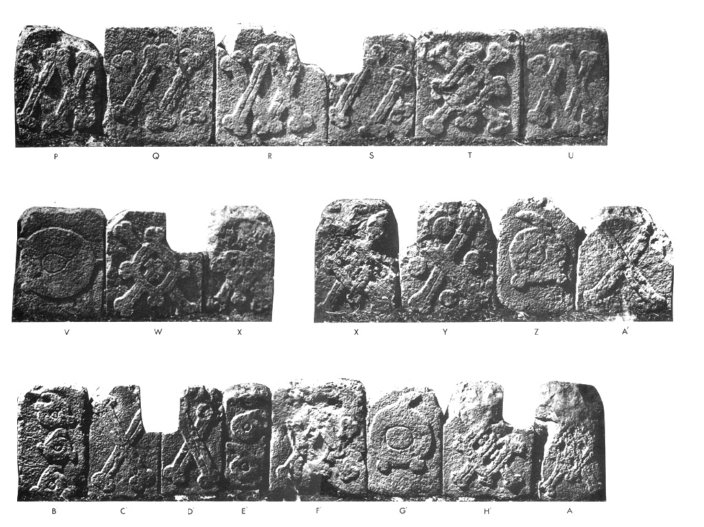
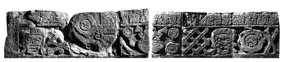
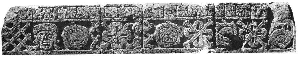
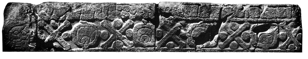
The four platforms were constructed in the courtyard of the Cementeria Group, in front of Str. IlL-B. Monument 1 was built against a low terrace on the west side of the temple stairway, and thus has carving on only three sides. Monuments 2-4 are free-standing.

Condition

The degree of completeness of the platforms as restored by Morley is most dearly appreciated by reference to the detail plan on this page. The disorder in which the blocks previously lay is evident from four photographs by Maler published by SeIer (1917, plates 31-33), in which many of the blocks of Mon. 3 can be seen lying upside-down. The extent to which the blocks constituting the four platforms have survived intact, and their state of preservation, should be evident from the drawings and photographs.

Material

Limestone.

Shape

The blocks forming Monuments

I, 3, and 4 resemble in form the typical block of a hieroglyphic stair except for their greater height and the much narrower lower border, which indicates that the blocks were set directly upon the

floor of the court, or embedded in it to a very shallow depth. The stones of Monument 2 differ in not having borders, and in having slots cut here and there into their upper edge, as if to accommodate some form of projecting framework, tenoned sculptures, drains, or other elements.

Carved Areas

Every block in the platforms (except those on the north side of Mon. 1) is carved on the exterior face.

Only Mon. 2 lacks a hieroglyphic band; photographs of it are included here for completeness and for comparative purposes.

Photographs

Graham. A photograph of unknown provenience has enabled the fragment now missing from the upper left comer of Block M of Mon. 3 to be replaced.

Drawings

Graham.

Drawing of Uxmal Monument locations

Capstone 1

Drawing of Uxmal, Capstone 1, 2004.15.15.1.336

Drawing of Uxmal, Capstone 1, 2004.15.15.1.336


Location

The central capstone in the northwest chamber of the east range of the Manjas Group. It was drawn first by Morley, who recorded the text in a pencil drawing (Notebook VI, no. 6, p. 26. Pea­ body Museum Archives) that was later published (1920, p. 511). A drawing of the whole design was published by Blom (1934, pl. III, fig. 3).

Condition

When discovered, the inscription was quite well preserved, whereas little remained of the "dancing" figure beyond its lower legs and elements of dress and ornament.

Material

Painted on stucco applied to a limestone slab.

Dimensions

Unknown.

Photographs

Kowalski.

Drawing

Redrawn by Graham from J. E. S. Thompson's version of Blom's original drawing. Lower line of text has been modified to incorporate the small changes suggested by Kowalski (1990, p.28).

Capstone 2

Drawing of Uxmal, Capstone 2, 2004.15.15.1.337

Drawing of Uxmal, Capstone 2, 2004.15.15.1.337


Location

This painted capstone was found by Blom in the inner room of the structure that he called Building Y (Structure 11M-18), located immediately to the east of the stairway up to the north range of the Monjas Group. A drawing was published by Blom (1934, pl. III, fig. 4).

Condition

When discovered, about two-thirds of the inscription was well preserved, and about the same proportion of the dancing or prancing figure remained. Its present state can be estimated from Kowalski's photograph, reproduced here.

Material

Presumably a painting on stucco applied to a limestone slab.

Dimensions

Unknown.

Photograph

Kowalski.

Drawing

One, redrawn from Blom (1934); the other redrawn from his preliminary sketch (MARI Archives, Tulane University).

Capstone 5

Drawing of Uxmal, Capstone 5, 2004.15.15.1.338

Drawing of Uxmal, Capstone 5, 2004.15.15.1.338


Location

Blom was the first to notice the painting on this capstone in Structure llM-21, the south range of the Nunnery Quadrangle. It is the center capstone of the north-facing chamber nearest the entrance passageway on its east side.

Condition

Evidently damaged in part when discovered, but otherwise well preserved. Present condition unknown.

Material

Painted stucco on limestone.

Dimensions

Unknown.

Photograph

None.

Drawing

Redrawn from Blom's sketch (MARl Archives, Tulane University).

Capstone 6

Drawing of Uxmal, Capstone 6, 2004.15.15.1.339

Drawing of Uxmal, Capstone 6, 2004.15.15.1.339


Location

Blom was the first to record the painting on this capstone, which is placed at the center of the most easterly north-facing chamber in Structure 11M21, the south range of the Nunnery Quadrangle.

Condition

Fragmentary when found; present condition unknown.

Material

Painted stucco on limestone.

Dimensions

Unknown.

Drawing

Redrawn from Blom's sketch (MARl Archives, Tulane University).

Mural 1

Drawing of Uxmal, Mural Painting 1, 2004.15.15.1.340

Drawing of Uxmal, Mural Painting 1, 2004.15.15.1.340


Location

Painted on the inner surface of the west wall of the middle chamber of the north building of the Casa de los Pajaros. Seler describes it as "a single (or double?) row of hieroglyphs, painted below the soffit with red color on a white background" (1917, p. 79).

Condition

Evidently only a fragment of a longer inscription, which has now disappeared altogether, save for vestiges of a red border.

Material

Paint on stuccoed wall.

Dimensions

Unknown.

Photograph

None.

Drawing

Redrawn from SeIer (1917, fig. 75b).

Misc 76

Drawing of Uxmal, Miscellaneous 76, 2004.15.15.1.341

Drawing of Uxmal, Miscellaneous 76, 2004.15.15.1.341


Photo of Uxmal, Miscellaneous 76, 2004.15.5.10.4

Photo of Uxmal, Miscellaneous 76, 2004.15.5.10.4


Location

Found by Ruz (1954, pp. 62, 63; fig. 6; pI. XXIV) while excavating the platform in front of the Palace of the Governor from which Stephens had extracted the two-headed jaguar. Scattered throughout the fill were a large number of fragmented offerings, including the remains of six other onyx vases. Now in the Merida Museum, Palacio Canton.

Condition

The pedestal base is intact, but only about half of the rest of the vessel survives, and its thin walls are broken into many rectangular pieces. About seven-eighths of the carved panel survives, but since Ruz photographed it a small fragment bearing a sixth glyph in the horizontal row has been lost. Erosion is scarcely perceptible.

Material

Mexican onyx, or tecalli.

Shape

Inverted conical frustum on low pedestal.

Carved Areas

Rectangular panel occupying about one-sixth of the bowl's circumference.

Photographs

Graham.

Drawing

Graham, based on his firsthand drawing.

Remarks

Karl Mayer (1989) has published a short article on this vase, with drawing by Nikolai Grube, in which it is referred to as Uxmal, Miscellaneous Text 1.