Ixtutz

Location and Access

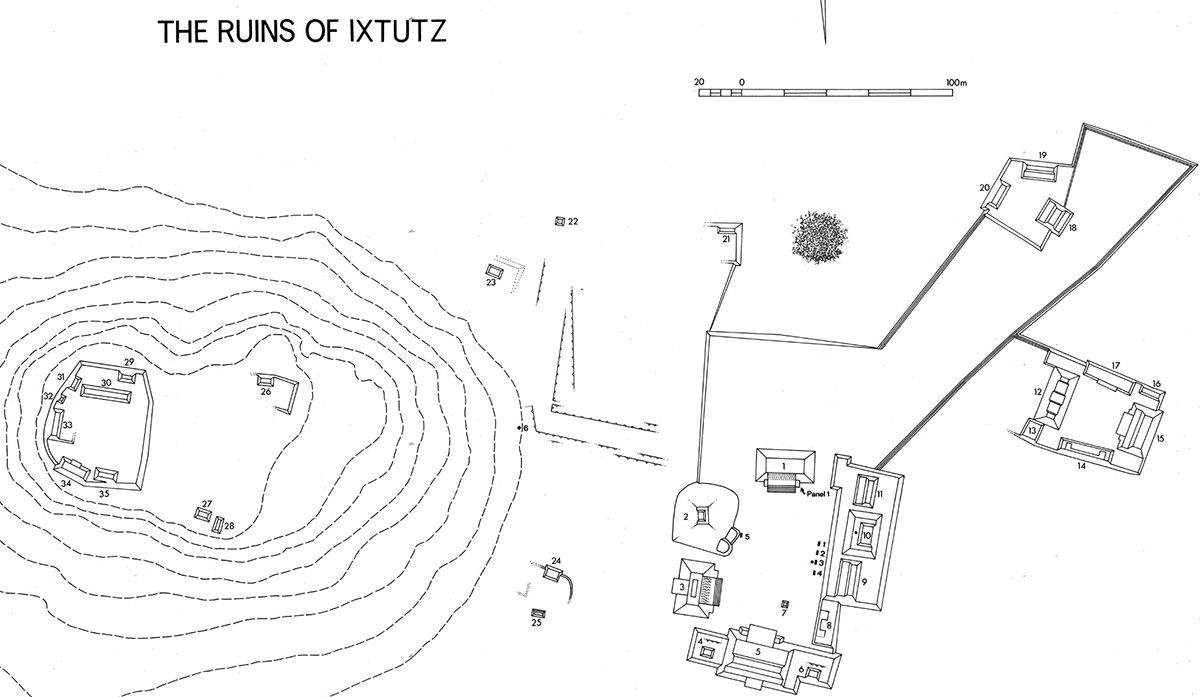
The ruins lie some 8 km southeast of Dolores, in southeastern Peten. Two trails lead to them from the Flores-Poptun road. One trail passes through La Borrachera, an abandoned house site named for some forgotten event, and distinguished besides by having a well in the form of a hole 2 m in diameter, dug down through the mud and stones to water at a depth of 3 m. The other route skirts a large mound (marked x on the area map) built upon a high terrace. I have not examined this mound.

The ruins are found in a small flat area surrounded by hills typical of a karst zone. Structures 26 to 35 are built on one of these hills. Apart from the well already mentioned, other sources of water are the aguada (not always dependable) shown at the northeast corner of the site plan and another lying between Structures 20 and 21, which collects water only during the rainy season.

Map of Ixtutz

Principal Investigations at the Site

The first published mention of this site resulted from the visit of Colonel Modesto Méndez and Eusebio Lara in 1852. In a report published in a German journal (Ritter 1853) "Yxtutz" is stated to be south of Dolores, and two of the stelae, numbers 1 and 3, are illustrated in somewhat fanciful drawings, but little other information is given. Following Méndez and Lara's visit, the ruins relapsed into oblivion for more than a century; then in 1970 a Maya who farmed milpa land nearby brought Merle Greene Robertson to the site. She revisited the site twice in the following year to make rubbings of the sculpture and to map the site, soon afterward publishing a report on it (Robertson 1972).

Having been told by her of Ixtutz, von Euw and I visited it in 1972. Von Euw, who preceded me to the site by a few days, began his work by transporting the blocks of the mosaic wall panel (Panel 1) by pack mule to Dolores. Following my arrival, we made our own plan of the site and recorded the monuments, including Stela 4, which we found to be carved on the underside. Considering this stela also worth rescuing, we engaged men to cut a roadway to the savanna flanking the Flores highway, and achieved our purpose with a truck provided by the Guatemalan army.

Notes on the Ruins

Ixtutz has a clearly defined main plaza bounded by the largest structures of the site where all the sculptured monuments are found. Also within the plaza is one plain stela, the fallen Stela 5 (original height ca. 2.25 m, MW 0.75 m, MTh 0.27 m). One of these structures, number 2, is clearly an adaptation of a natural feature; the rest may have been constructed on level ground. On top of Structure 2 there is a well-preserved platform 0.70 m high, built of neatly cut stones of varied sizes and shapes. Any building supported by this platform could only have been of perishable materials.

The level, and probably at one time plaster-roofed, ceremonial plaza area has an extension toward the northeast that forms an enclosed precinct having some of the character of a causeway. With it are associated a small plaza group and a plazuela.

From the northwest corner of the main plaza a short causeway, or ceremonial way, bounded by very low walls, leads to the foot of a hill that rises to a height of 45 m. At its foot, above a wide step that seems to terminate the causeway, stands a stone shaft, set diagonally, the sides of which measure about 1.0 m by 1.1 m. Since this may have been set up for ceremonial purposes it is marked on the plan as Stela 6.

Notes on the Plan of the Site

The density of undergrowth found at this site at the time of our visit (due to the destructive hurricane of 1961) made surveying more difficult than usual. For this reason, perhaps, there is some lack of agreement between Merle Greene Robertson's plan and ours, especially in the area lying between the causeway that runs to the foot of the hill and a line joining our Structures 21 and 22 (a renumbering of structures for our plan was unavoidable). Robertson also shows a group of four mounds on a common platform south of our Structure 25, which we missed.

A symbol employed in the plan but not shown in the table of site plan symbols (p. 1:26) needs to be explained. A line punctuated by small sawteeth denotes a single step in isolation, such as might be found between two plaza areas of different level, or one edge of a low and broad causeway wall. The sawtooth element was inspired by the generally triangular shape of the stones often used by the Maya to form such features. Thus the sawteeth point toward the higher level.

Register of Inscriptions at Ixtutz

Stelae 1-4
Panel 1

References Cited

RITTER, CARL

1853    "Ueber neue Entdeckungen und Beobachtungen in Guatemala und Yuca-tan," Zeitschrift, Gesellschaft für Erdkunde zu Berlin, vol. I, pp. 161-193. Berlin.

ROBERTSON, MERLE GREENE

1972    "Notes on the Ruins of lxtutz, Southeastern Peten" (with an Appendix by John A. Graham), Contributions of the University of California Archaeological Research Facility, no. 16, pp. 89-104. Berkeley.

Inscriptions at Ixtutz

Stela 1

Photo of Ixtutz, Stela 1, 2004.15.5.4.18Drawing of Ixtutz, Stela 1, 2004.15.6.4.14

Left: Photo of Ixtutz, Stela 1, 2004.15.5.4.18
Right: Drawing of Ixtutz, Stela 1, 2004.15.6.4.14


Location

Still standing, the stela is the northernmost in a line of four stelae on the west side of the platform on which Structures 9, 10, and 11 are built. It was first reported by Modesto Méndez.

Condition

Intact, but severely eroded.

Material

Limestone.

Shape

A poorly fashioned shaft, flat-topped, with approximately parallel sides.

Dimensions

 
HLC
2.36 m
 
PB
unknown
 
MW
1.11 m
 
WBC
0.94 m
 
MTh
0.38 m
 
Rel
0.6  cm
 

Carved Areas

Front only.

Photograph

Graham, 1972.

Drawing

Graham, based on a field drawing corrected by artificial light.

Stela 2

Photo of Ixtutz, Stela 2, front, 2004.15.5.4.19Drawing of Ixtutz, Stela 2, front, 2004.15.6.4.15

Top: Photo of Ixtutz, Stela 2, front, 2004.15.5.4.19
Bottom: Drawing of Ixtutz, Stela 2, front, 2004.15.6.4.15


Location

Second from the northern end of four stelae on the western side of the platform on which Structures 9, 10, and 11 are built. The stela lies on its back with the butt still in situ, as it did when first reported by Merle Greene Robertson.

Condition

Broken into three extant pieces: the main body of the shaft, one small fragment, and the butt carrying a small portion of the design. Other small fragments are lost. A vertical fissure runs down the middle of the sculptured face, the surface of which is severely eroded.

Material

Limestone.

Shape

Tapers slightly toward the bottom; the top is flat.

Dimensions

 
HLC
2.77 m
 
PB
unknown
 
MW
1.40 m
 
WBC
1.17 m approx.
 
MTh
0.38 m
 
ReI
1.7  cm
 

Carved Areas

Front only.

Photograph

Graham, 1972.

Drawing

Graham, based on a field drawing corrected by artificial light.

Stela 3

Photo of Ixtutz, Stela 3, front, 2004.15.5.4.20Drawing of Ixtutz, Stela 3, front, 2004.15.6.4.16

Left: Photo of Ixtutz, Stela 3, front, 2004.15.5.4.20
Right: Drawing of Ixtutz, Stela 3, front, 2004.15.6.4.16


Location

The stela lies broken with its carved face up, the second from the southern end in a line of four stelae on the west side of the platform on which Structures 9,10, and 11 are built. As Lara attempted to draw the stela, it may be that the stela was still erect in 1853. In front of this stela is a plain circular altar 1.55 m in diameter and 0.46 m thick.

Condition

The top of the shaft is broken into three fragments, and the butt is broken off at the base of carving. The surface is severely eroded.

Material

Limestone.

Shape

Slightly bulging sides, with a rounded top.

Dimensions

 
HLC
2.80 m
 
PB
1.47 m
 
MW
1.16 m
 
WBC
1.06 m
 
MTh
0.27 m
 
ReI
4.5  cm
 

Carved Areas

Front only.

Photograph

Graham, 1972.

Drawing

Graham, based on a field drawing corrected by artificial light.

Stela 4

Photo of Ixtutz, Stela 4, front, 2004.15.5.4.21Drawing of Ixtutz, Stela 4, front, 2004.15.6.4.17

Left: Photo of Ixtutz, Stela 4, front, 2004.15.5.4.21
Right: Drawing of Ixtutz, Stela 4, front, 2004.15.6.4.17


Location

Found lying on its face (i.e., fallen toward the west), the southernmost in a line of four stelae on the west side of the platform on which Structures 9, 10, and 11 are built. The stela was removed in 1972, first to Tikal, and later to the Museo Nacional de Arqueología y Etnología, Guatemala.

Condition

Intact, except perhaps for the loss of the bottom of the butt. The upper part of the inscription is in almost pristine state, although lower down much of it has been lost through flaking.

Material

Honey-colored limestone.

Shape

Evidently intended to have a symmetrical, tapered shape, the shaft appears to have had a defective upper left hand corner even before it was carved.

Dimensions

 
HLC
1.83 m
 
PB
0.33 m plus
 
MW
1.16 m
 
WBC
1.02 m
 
MTh
0.40 m
 
Rel
1.0  cm
 

Carved Areas

Front only.

Photograph

Graham, 1972.

Drawing

Graham, based on a field drawing corrected by artificial light.

Panel 1

Photo of Ixtutz, Panel 1, 11 blocks, 2004.15.5.4.22

Drawing of Ixtutz, Panel 1, 11 blocks, 2004.15.6.4.18

Top: Photo of Ixtutz, Panel 1, 11 blocks, 2004.15.5.4.22
Bottom: Drawing of Ixtutz, Panel 1, 11 blocks, 2004.15.6.4.18


Location

The constituent blocks of this incomplete mosaic panel were found by Robertson among rubble on the south side of Structure 1, east of the stairway. Intending to remove them to safety by helicopter, she assembled all that could be found without excavation. Von Euw, however, took them to Dolores with pack mules. The blocks were then removed from Dolores by the Instituto de Antropolagía e Historia.

Condition

Many elements of the panel are missing, perhaps still buried in debris. Robertson (1972, p. 94) states that fifteen fragments were found; we have a record of eleven, some of which are in excellent condition, others broken or badly weathered.

Material

Limestone.

Shape

The undamaged blocks are rectangular and neatly trimmed.

Dimensions

The width of the undamaged blocks varies between 0.29 and 0.37 m, the thickness between 0.20 and 0.50 m. The depth of relief runs up to 7.0 cm.