Coba Vol. 8.1
Ian Graham and Eric von Euw 1997 Peabody Museum Press
The ruins of Coba lie 44 km northwest of Tulum, in the State of Quintana Roo, Mexico. The geographical coordinates of Grupo Coba, the central group within this extensive site, are North 19° 29.6’ and West 87° 43.7’. The archaeological zone is reached by a two-kilometer branch from the asphalt road connecting Tulum with Nuevo X-Can on the Valladolid to Cancún highway. For many years, a road conveniently leading from Chemax to Coba has been marked on some road maps; alas, it was imaginary. But recently, construction of an actual highway linking those towns has started. It may be noted that in keeping with the policy of this work (based on the fact that accents are unnecessary in Maya languages), all names of Maya origin applied to archaeological sites, rather than towns, remain unaccented.

The first mention of Coba in print is due to John Lloyd Stephens (1843, vol. 2, pp. 340, 341). In 1842, Stephens, with his companions Frederick Catherwood and Samuel Cabot, had set out from Chichen Itza heading east,Tulum being their intended destination. On their way, the cura of Chemax showed them a report describing his parish, in which it was stated that at a distance of eight leagues and near one of three lakes, there lay a ruined city named Coba. In it was a building that the Indians called the Monjas, which consisted of various ranges of two stories, all roofed with arches finished with masonry of rough stone, the size of the rooms being six square yards. The floors were intact, and on the walls of one second-story room were painted figures in various attitudes. From that building there was a calzada, or paved road, ten or twelve yards wide, running–and here was the only serious error–towards the southeast to a terminus that had not been established, but some argued that it went in the direction of Chichen Itza.

For once, Stephens chose not to follow up an enticing lead, perhaps for lack of a guide with firsthand knowledge of the site; besides, his goal was Tulum, and he was worried that his worn shoe leather might not carry him even that far.
Another forty years would pass before a visitor seriously interested in Coba was to reach the site. This was Juan Peón Contreras (or Contreras Elizalde as he also styled himself), who was then director of the Museo de Yucatán (Millet 1988). He made the arduous journey in September 1882, and is now remembered for the four naive pen-and-ink sketches that he made at the ruins (prints made from them exist in the Peabody Museum and in the collection of Raúl Pavón Abreu in Campeche).
Nine years later, Teobert Maler visited Coba. The legacy of his two-day visit is a description written in Spanish (Maler 1932 and 1944), plus a single surviving print of his photograph of the temple on top of Structure C-l (Benavides 1981b, fig. 19).
The next visitor of consequence was Thomas Gann, M.D., an amateur archaeologist and writer of successful popular books wherein he described his adventures and discoveries among Maya ruins. In February 1926, while serving as an honorary member of the Carnegie Institution of Washington (CIW) staff working at Chichen Itza, Gann took time off to visit Coba, accompanied by E. L. Crandall, a photographer employed by the CIW. In his next book he would describe many features of the ruins for the first time and publish sketches of three hieroglyphic tablets found while journeying along the sacbe, or ancient roadway (Gann 1926, pp. 111-113). Photographs of these tablets and three others were later published by Alfonso Villa Rojas (see below).
In describing the ruins upon his return to Chichen Itza, Gann spoke of the large mounds he had sighted, but not visited for lack of time, lying to the northeast of the main group. It was to examine these that Alfred Kidder and Eric Thompson went for a two-day inspection of the site in March. Two months later Thompson was again at Coba, forming with Jean Charlot the Third CIW Expedition. On this trip their guide, Carmen Chai, showed them the Macanxoc Group, a discovery that led to the departure of the Fourth CIW Expedition, since Sylvanus Morley wanted Thompson to show him the new stelae (Morley 1926, pp. 274-277).
In February 1929, the Fifth CIW Expedition briefly visited Coba, consisting only of Harry Pollock and field assistants. A year later, again in February, Pollock returned with Thompson for a three-week sojourn, the latter accompanied by his wife on their honeymoon. In July of the same year Pollock was back in Coba for two weeks, accompanied by Gustav Strömsvik.
In 1932 H. B. Roberts opened a number of trenches in Group B to collect sherds (Brainerd 1958, p. 10).
None of these expeditions to Coba lasted more than three weeks–most of them only a matter of days–yet the amount of information compiled and presented in A Preliminary Study of the Ruins of Cobá, Quintana Roo, Mexico (Thompson et al. 1932) is truly impressive.
Over the next forty years, additions to this body of knowledge were few. In 1933 Villa Rojas, workmg for the CIW, confirmed Thompson’s speculation that the destination of Sacbe 1 might be Yaxuna. Starting at Yaxuna with six helpers, he plotted the 100-km course of the causeway, noting features along the way, including SIX hieroglyphic tablets spaced at roughly kilometer intervals over a stretch lying between 15 and 10km west of Coba (Villa Rojas 1934, pp. 206, 207).
In July 1937, the young E. W. Andrews IV spent two weeks at the site with two friends. They discovered Stela 24 (Andrews 1938), and a shaft perforated with a square hole, later designated by Navarrete as Stela 26 (Navarrete et al. 1979, p. 69). They followed Sacbe 15 to its terminus, a large structure in a group which Andrews named Kitamna, and they discovered Sacbe 17.
In 1938, Cyrus Lundell leading the CIW Botanical Expedition to Quintana Roo (Lundell 1938), discovered Stela 28. He also mentioned an interesting find in one of the plazas: an orange grove, apparently long established, in the shade of high ramón forest. This confirms a report of orange trees at Coba in the 1890s (Folan 1983, p. 3). At the time of the Thompson’s and Pollock’s visits there was no resident population, merely a seasonally occupied chiclero camp, but thatched houses are shown on the lakeshore in one of the Contreras’s drawings. The "so-called old Spanish walls" reported in the site by Pollock (1930, 24 February) may confirm the existence of an earlier occupation in historic times, although it is conceivable he mistook pre-Columbian boundary walls for colonial or nineteenth century dry-stone walls.
Lundell also describes a vast area of land to the west of Coba as desolate, the result of annual dry-season fires for at least the six preceding years, with a few remaining fire-resistant species attesting to old high forest. The mantle of soil had eroded, leaving barren stretches of pitted white limestone. East of Coba, fire destruction had been less severe. He mentions, too, the new "emergency airfield," which extended along the north side of Grupo Coba. It was almost certainly built for Pan-American Airways when their long range service into Latin America was being developed; a similar emergency field was maintained, complete with drums of aviation gasoline, at La Libertad, Peten, until the 1960s.
In 1948 two graduate students in archaeology, William and Michael Coe, visited Coba, intent on seeking the terminus of Sacbe 15. They were unaware, unfortunately, that Andrews had already reported it. In an editor’s note following their report (Coe and Coe 1949) Thompson blames himself as editor for failing to detect the repetition of prior work in their contribution, while excusing the young authors for ignorance of a paper published in a foreign journal. But the Coes reported the previously unknown Sacbes 18 and 19 and mapped the large mound at the terminus of Sacbe 17, which they named Pech Mul (they were unlucky again in failing to complete their circuit of its platform, or they might have discovered the sacbe leading out of it, no. 21).
In 1972 the Instituto Nacional de Antropologi;a e Historia began a program of investigation and later of consolidation at Coba, in response to the planned hotel development at Cancún, and at the urgings of Infratur, government-backed agency charged with developing the infrastructure for tourism; disappointingly, no sister agency was created to support archaeology (it might have been Infradig).
The first phase was carried out by Carlos Navarrete, Maria José Con, and Alejandro Martinez Muriel in September and October 1972 (Navarrete et al. 1979). Their mission was to survey the actual state of the site, establish boundaries for the portion to be declared an archaeological zone, and plan the pathways and cleared areas. The boundaries of the park that was later created are illustrated by Alfredo Barrera Rubio (1976, p. 9).
Expectations of new discoveries were borne out when El Cono (StructureD-6 ) and Grupo Las Pinturas came to light, among other features. In the same year, much of Grupo Coba was cleared on the instructions of Raúl Pavón Abreu; not even its tall ramón trees were spared.
In 1975 a branch road from the asphalted highway being built from Tulum to Nuevo X-Can reached Coba (fortunately the road engineers heeded objections by archaeologists and abandoned their original plan of incorporating Sacbe 3 in the roadbed). A project camp was built in 1973, and in 1974 the Proyecto Coba proper, under the auspices of the Centro Regional del Sureste of INAH and directed by Norberto González Crespo, was able to begin its operations. The first field director was Piedad Peniche, followed in 1975 by Antonio Benavides. During the three-year existence of the project, portions of the site were cleared and structures excavated and consolidated, (the Castillo and the Pinturas Group by Peniche; the Iglesia by Benavides and Jaime Garduño; El Cono by Benavides and Fernando Robles); the sacbes were investigated by Folan and by Benavides, who added 26 to the list of 19 previously known; the ceramics from test pits and trenches were studied by Robles (1980); and Jaime Garduño (1979) surveyed two transects of the site, one of 10 km north-south and another of 5 km east-west.
A separate but contemporary project was the Proyecto Cartográfico Arqueológico de Coba under the join direction of William J. Folan and George Stuart of the National Geographic Society, which funded it (Folan and Stuart 1977 and Folan et al. 1983); this is further described below.
In 1975 an independent study of wall paintings at the site was made by Marine Fettweiss (1980, 1988).
In 1989 investigation and consolidation of the secondary stairway of the Castillo was carried out by Luis Leyra Guillermo, and in 1992 INAH inaugurated a new program of clearing and consolidating the structures forming the eastern side of the plaza of Grupo Coba, this under the direction of Alejandro Martinez Muriel.
In about 1990 coring of sediments in Lago Coba was carried out, with determination of the limnological effect of human occupation in the drainage area as one of its purposes. At a depth corresponding to about 1900 B.P., highly eutrophic conditions were evident, following agricultural disturbance indicated by a high level of maize pollen (Whitmore et al. 1996, p. 278).
The record of sculpture presented in this fascicle is based on work by Eric von Euw during visits to the site in 1975, 1976, and 1978. His work was supplemented by Ian Graham in 1990, 1992, 1994, and 1996, these brief visits having been chiefly devoted to mapping.
Inscriptions at Coba
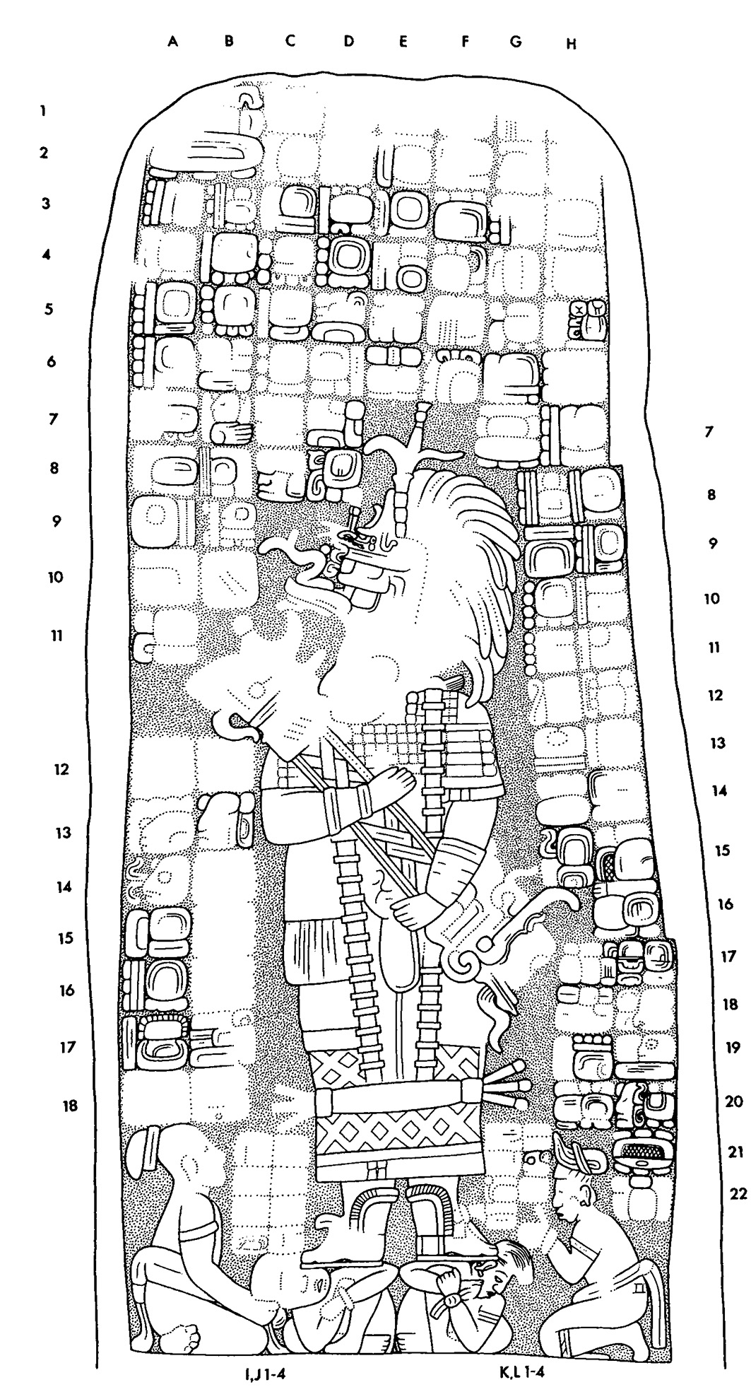

Drawing of Coba, Stela 1, left


Location
This stela was shown to members of the Third CIW Coba Expedition by Carmen Chai, their guide, in 1926. It stood, and still stands, in an enclosure built on a small platform, Structure A-9.
Condition
Intact. Some areas of the front are severely pitted; the back is in better condition.
Material
Limestone containing flaws, such as the void at Glyph B18.
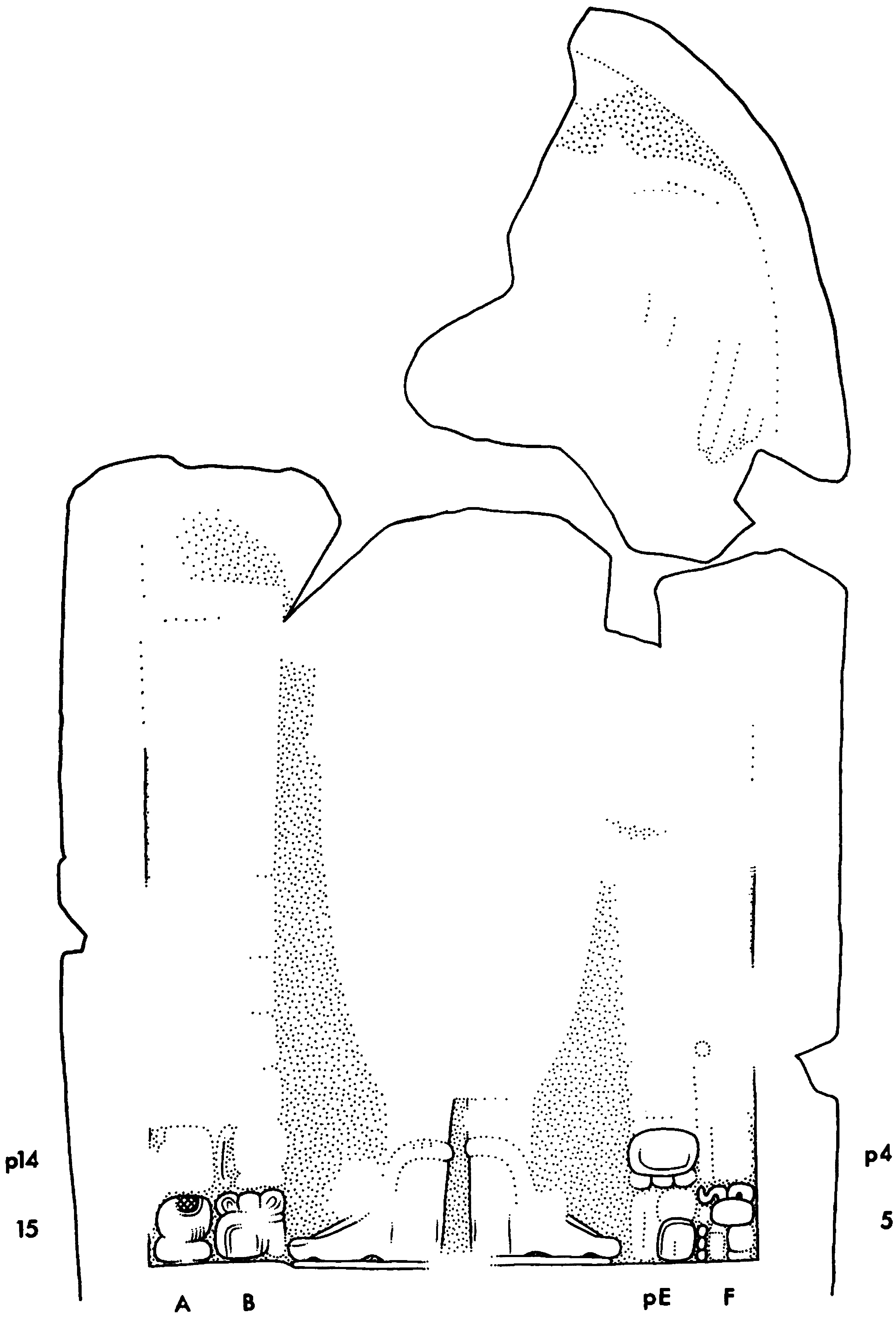
Shape
From the front, the sides converge slightly until, at three-quarters height, there is a discontinuity on the right-hand side. The top is flat with rounded corners. The front is somewhat convex; the back convex except lower down where it is concave. On the right-hand side, a layer of shells and other inclusions may have been responsible for displacement of the glyph column to the right, but we can suggest no explanation for its further displacement lower down.
Dimensions
HLC | 2.92 m |
PB | unknown |
MW | 1.43 m |
WBC | 1.43 m |
MTh | 0.36 m |
ReI | 2.5 cm |
Carved Areas
All four sides. On both sides, the inscriptions extend round their edges and onto the back of the stela, the most prominent in this respect being Glyphs W19-22.
Photographs
Graham; images of both sides are composites of two photos.
Drawing
Front and sides, von Euw, with revisions by Graham; back, Graham. All were based on von Euw's field drawings corrected by artificial light.


Location
Set in the middle of the second step of the stairway of the south facing Structure A-7.
Condition
Intact, and showing severe erosion and pitting over the entire surface, except at the very bottom.
Material
Limestone with some shell inclusions.
Shape
The shaft tapers asymmetrically and with discontinuities of outline towards a rounded top. The front is flat, and all four sides were carefully finished.
Dimensions
HLC | 3.01 m |
PB | unknown |
MW | 1.22 m |
WBC | 1.22 m |
MTh | 0.24 m |
ReI | 2.7 cm |
Carved Areas
Front only.
Photographs
von Euw; the image of the front is a composite of two photos.
Drawing
von Euw, based on a field drawing corrected by artificial light.

Location
Set on the west side of a small mound, Structure A-6.
Condition
Intact, but the surface is very badly eroded and pitted.
Material
Limestone with shell and other inclusions.
Shape
The sides taper slightly towards the rounded top with a gentle and symmetrical curve. The front shows some cylindrical convexity on a vertical axis.
Dimensions
HLC | 2.53 m |
PB | unknown |
MW | 1.27 m |
WBC | 1.27 m |
MTh | 0.30 m |
ReI | 2.5 cm |
Carved Areas
Front only.
Photographs
Graham; the image of the entire stela is a composite of two photos.
Drawing
von Euw, based on a field drawing corrected by artificial light.


Location
Found almost buried in rubble and reclining against the back wall of a shrine near the bottom of the north facing stairway that ascends a large temple mound, Structure A-2.
Condition
Intact; the upper part is badly eroded and pitted, the lower in good condition. Recently reset.
Material
Limestone of uniform composition.
Shape
Irregular. Evidently the upper left corner of the shaft was rounded and had a surface receding from the general plane of the front before sculpture was begun. Cross section of shaft is lenticular at foot.
Dimensions
HLC | 2.50 m |
PB | 0.10 m plus |
MW | 1.04 m |
WBC | 1.04 m |
MTh | 0.35 m |
ReI | 1.0 cm |
Carved Areas
Front only.
Photographs
Graham; that of front is a composite of three photos.
Drawing
von Euw, based on a field drawing corrected by artificial light.


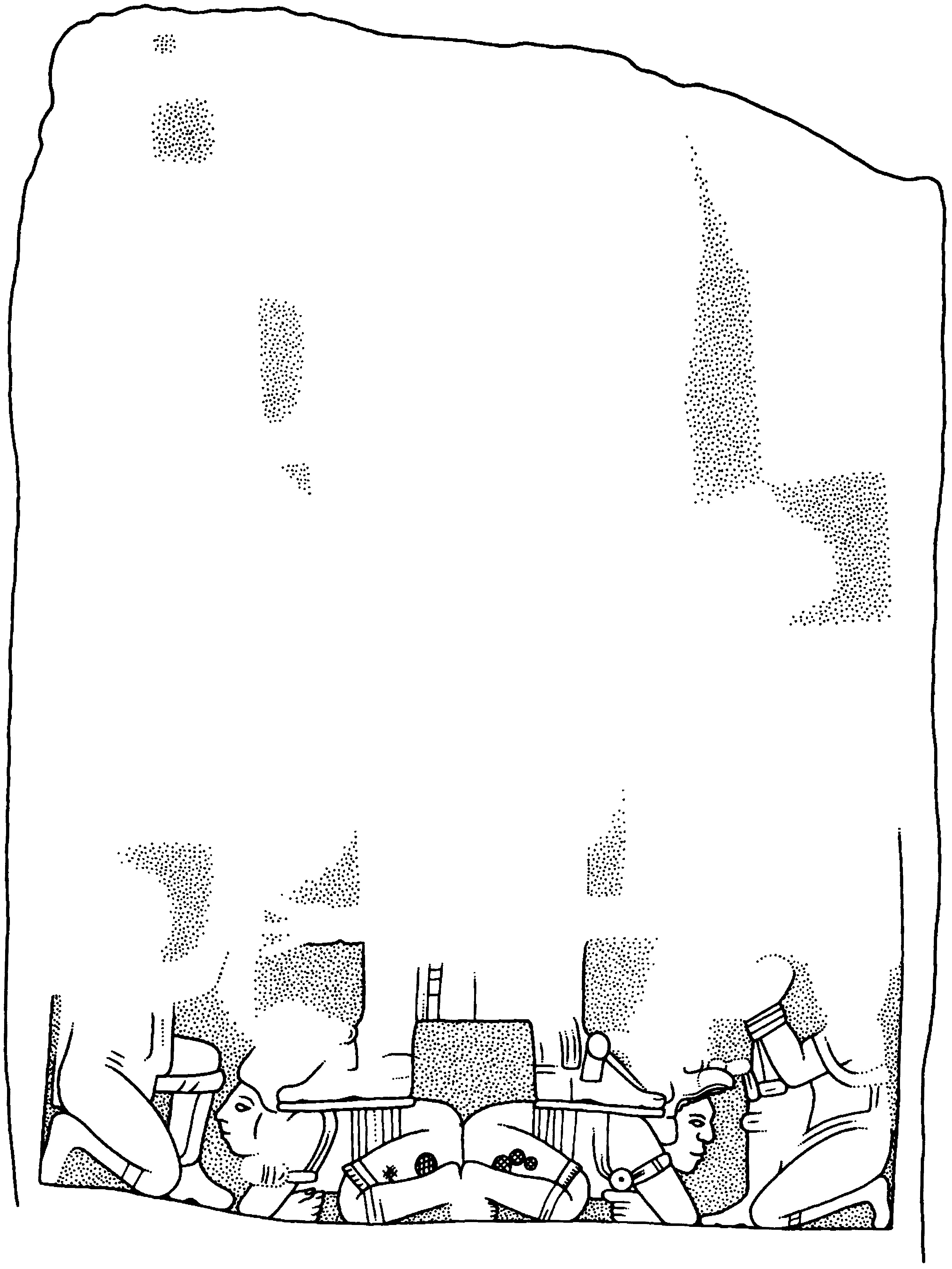
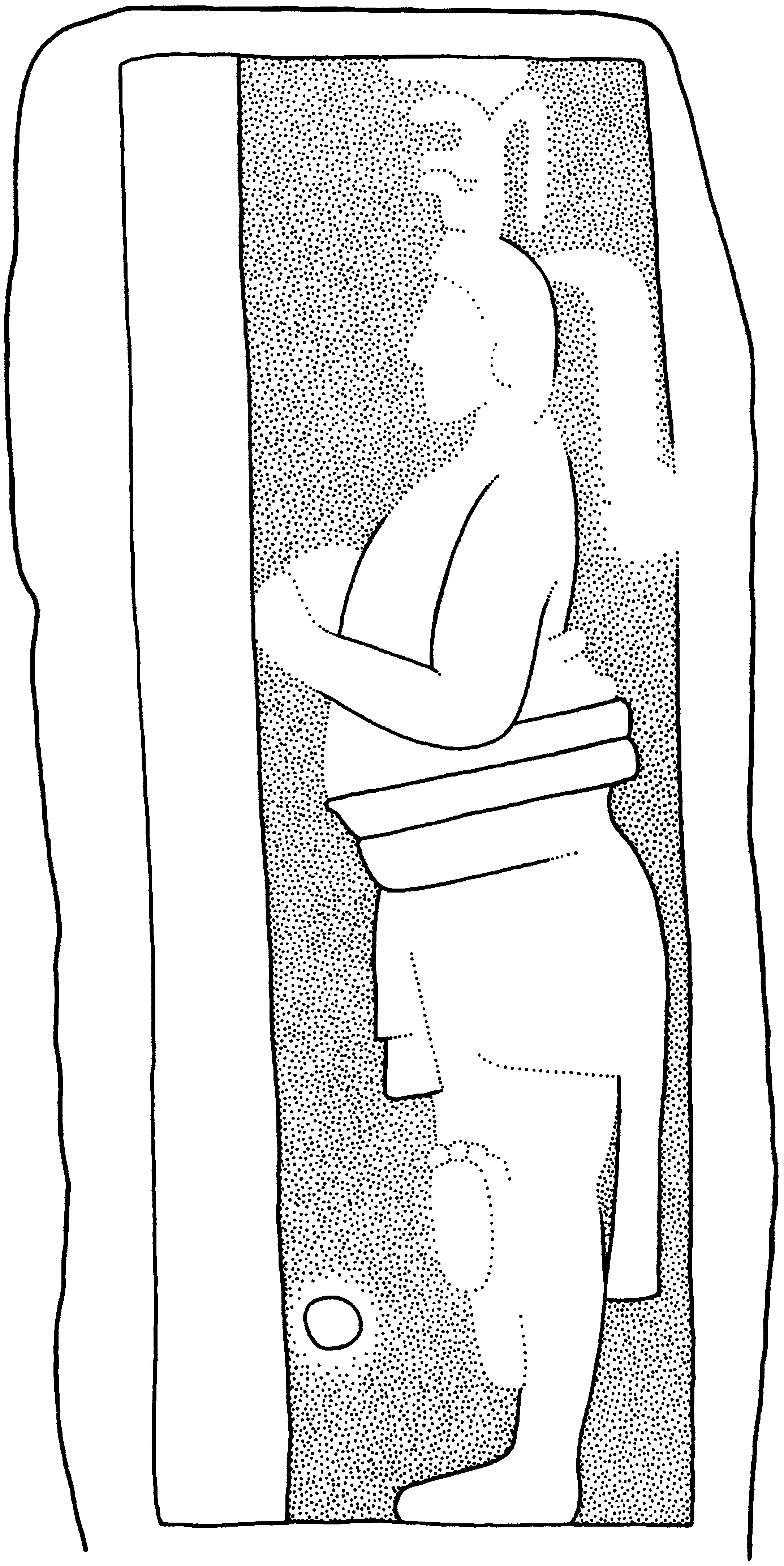
Location
Found on a low platform at the foot of the stairway leading up the west side of Structure A-3. The lower part was in situ, facing 213 degrees magnetic, whereas temple faces west.
Condition
Intact; Broken into two main and four small fragments and butt. Restored and re-erected in about 1980. Erosion varies from moderate to very serious, with much pitting. If the left side ever bore an inscription, it is now entirely obliterated.
Material
Shelly limestone.
Shape
The shaft bulges slightly up to its midpoint, then tapers symmetrically to a rounded top. The front and back are nearly flat except in the upper right-hand region, where the shaftÕs thickness is greatly reduced.
Dimensions
HLC | 2.50 m |
PB | 0.10 m plus |
MW | 1.04 m |
WBC | 1.04 m |
MTh | 0.35 m |
ReI | 1.0 cm |
Carved Areas
Front, back, right side and left side, at least.
Photographs
Graham.
Drawing
Front, von Euw with butt portion added by Graham; back, Graham. Both were based on drawings corrected by artificial light.

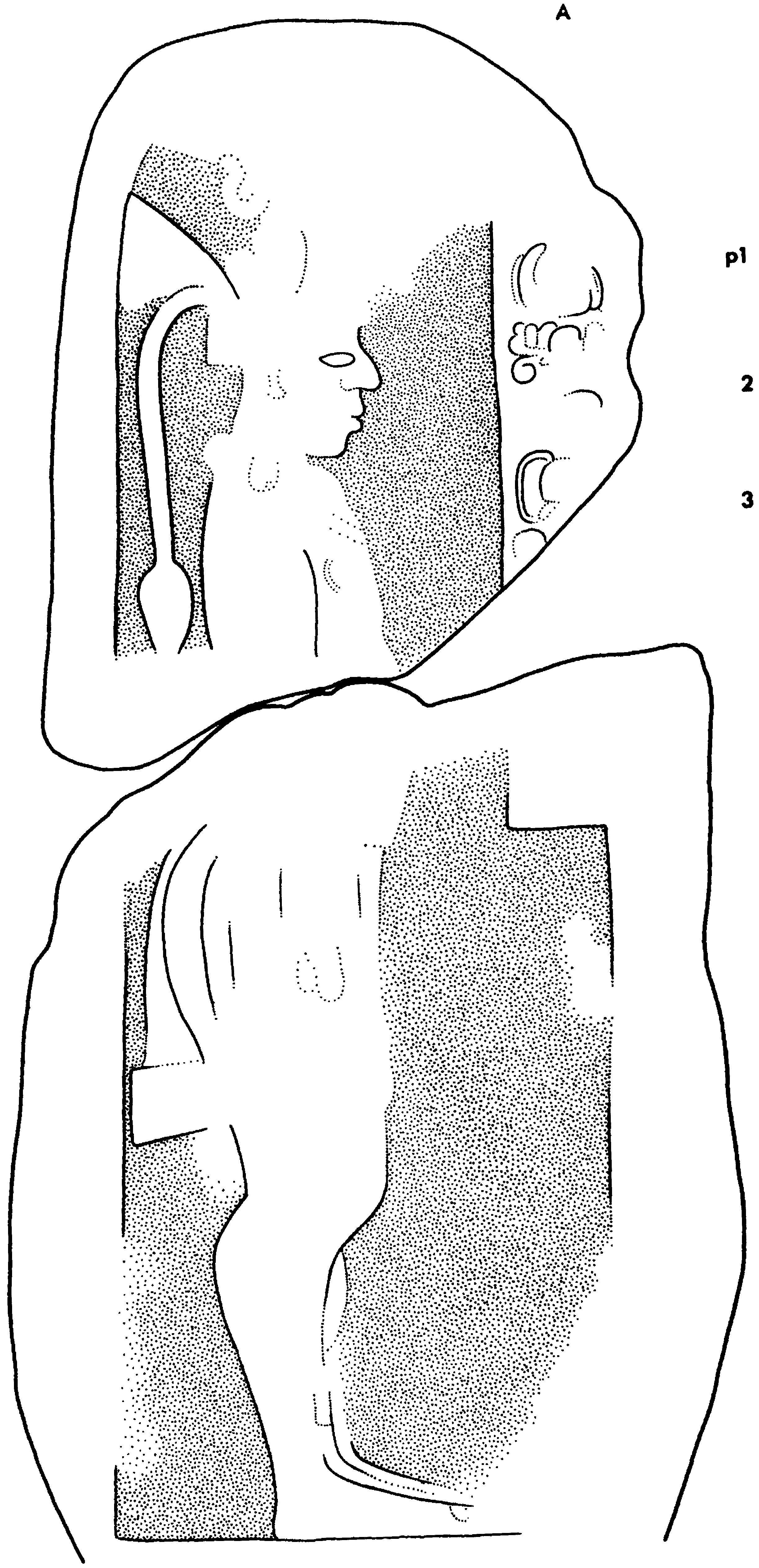
Location
This stela, broken and enveloped, by a tree, was found by the Third CIW Expedition. The fragments lay on the west side of Structure A-4, a range building forming one side of the court that surrounds an important temple, Structure A-5.
Condition
Broken into nine fragments. The lower half of the sculpted face is fairly well preserved, while the upper is badly eroded. The stela has been repaired and reset.
Material
Shelly limestone.
Shape
Sides parallel with rounded top. The front is flat, and the sides are well dressed.
Dimensions
HLC | 2.14 m |
PB EPB | unknown 0.38 m approx. |
MW | 1.12 m |
WBC | 1.04 m |
MTh | 0.30 m |
ReI | 2.4 cm |
Carved Areas
Front only.
Photographs
Graham.
Drawing
von Euw, based on a field drawing corrected by artificial light.

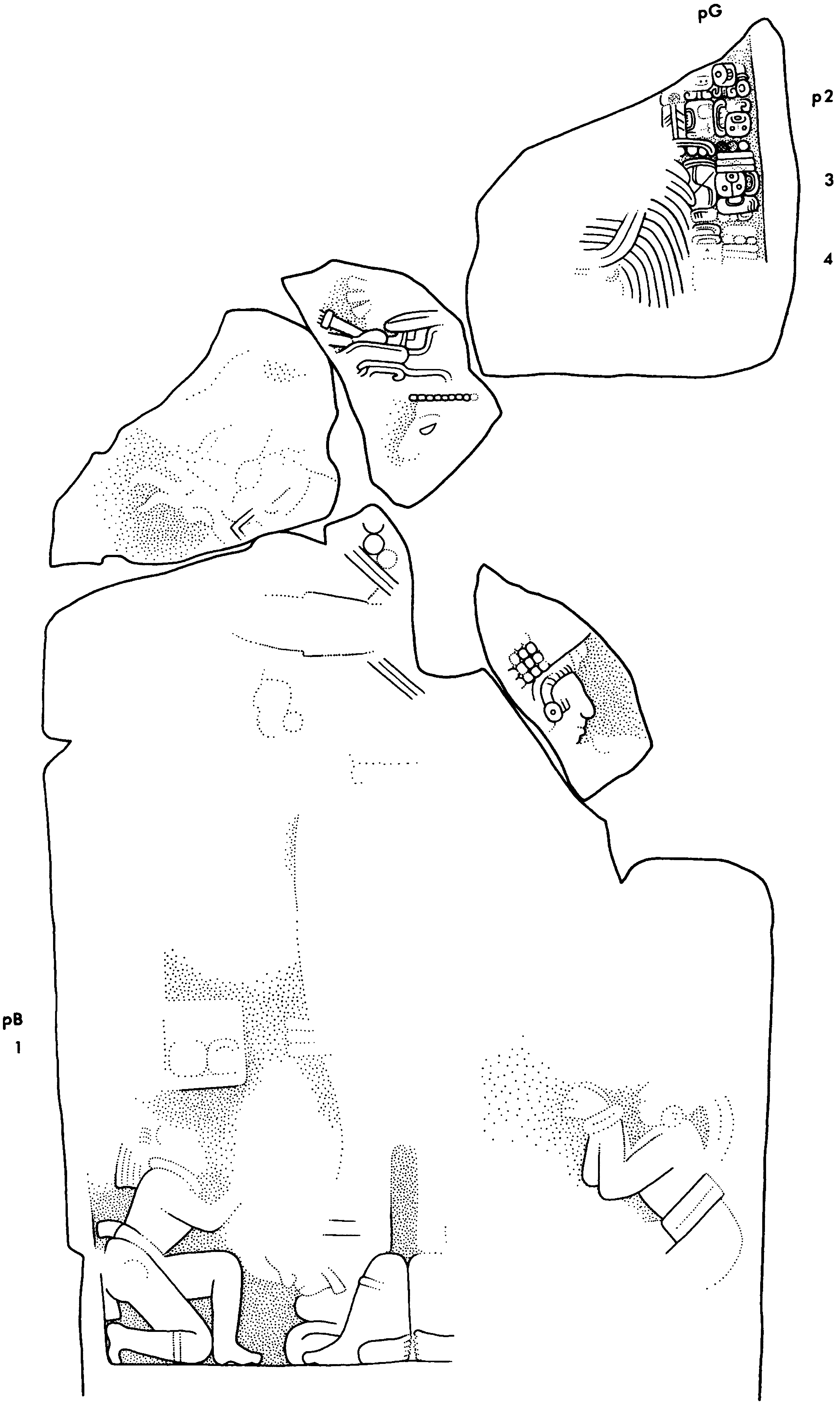
Location
Found in 1926 by the Third CIW Expedition; the stela was standing within a three-sided enclosure built on a low platform in the Macanxoc Group. The mound, Structure A-8, lies about 40 m east of Stela 1.
Condition
The known portion is in one piece, but it has almost certainly lost an upper fragment. Most of the carved surface has flaked off, leaving only a small area at the bottom in good condition.
Material
Limestone of fairly fine grain, but prone to flaking.
Shape
Parallel sides. The right-hand side and front were fairly well dressed; the other side may also have been, but is now damaged. The back was left rough.
Dimensions
HLC | 1.61 m |
PB | unknown |
MW | 1.29 m |
WBC | 1.29 m |
MTh | 0.29 m |
ReI | 3.0 cm |
Carved Areas
Front only.
Photographs
von Euw.
Drawing
von Euw, based on a field drawing corrected by artificial light.

Previous Designation
Stela 11 (Morley 1926, p. 275).
Location
The lower half was found in 1893 by Maler. It stands beside, and just to the north of, Stela 10 in a small enclosure, or shrine, built against the western side of Structure B-17, the Coba Group ball court.
Condition
The single known portion amounts to two-thirds or a half of the original. Owing to the nature of the stone, erosion has rendered the carved surface rough, and the design unclear.
Material
A fairly hard limestone containing many shells and other inclusions.
Shape
Sides nearly parallel. The front has been carefully dressed into a slightly cylindrical surface; the sides are fairly well shaped; and the back is irregular.
Dimensions
HLC | 1.11 m |
PB | unknown |
MW | 0.90 m |
WBC | 0.88 m |
MTh | 0.25 m |
ReI | 0.7 cm |
Carved Areas
Front only.
Photographs
von Euw.
Drawing
von Euw, based on a field drawing corrected by artificial light.

Location
The lower portion found in 1893 by Maler was standing in an enclosure, or shrine, built against the western side of the Coba Group ball court, with Stela 9 beside it to the north. A large fragment constituting most of the upper half was discovered in rubble nearby by Mart’nez in 1996.
Condition
Both portions show considerable erosion of the very low relief.
Material
Fairly hard limestone, but flawed with cleavage planes and cavities.
Shape
The sides are parallel, the front flat. The left side is well dressed; the right damaged and rougher; and the back rough.
Dimensions
HLC | 2.10 m approx. |
PB | unknown |
MW | 0.96 m |
WBC | 0.88 m |
MTh | 0.32 m |
ReI | 0.3 cm |
Carved Areas
Front only.
Photographs
von Euw and Graham.
Drawing
Graham, based on von Euw's drawing of the lower portion and on photographs.

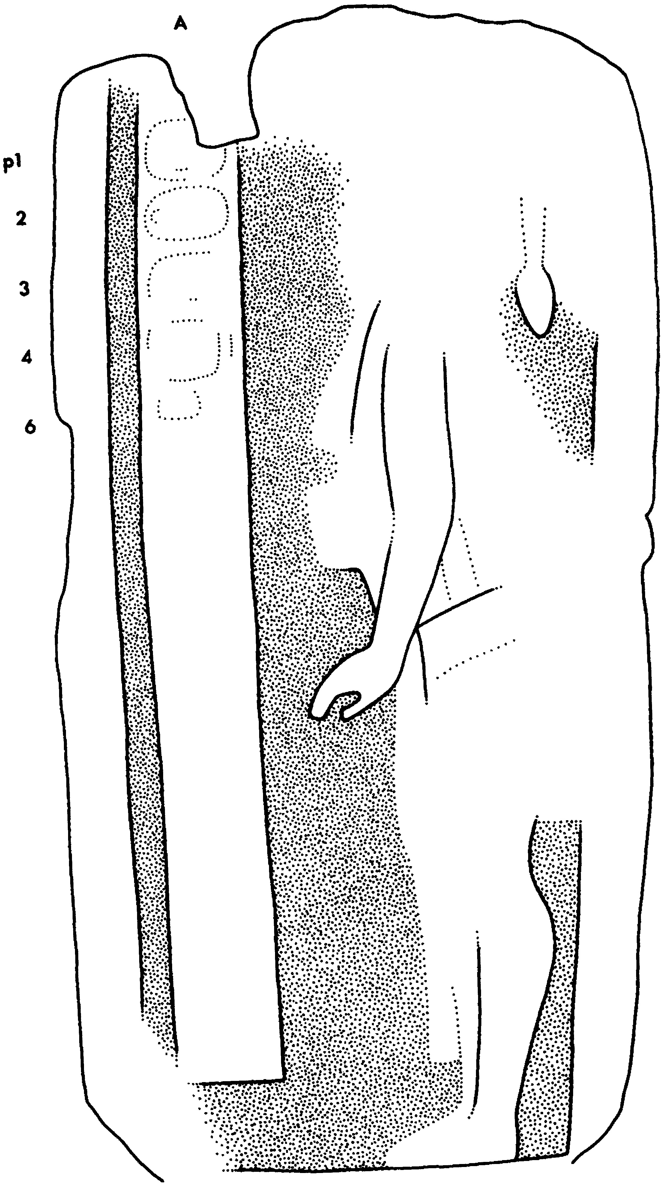
Location
Discovered in 1926 by Gann. The Stela was standing in a simple enclosure, or shrine, in Court A, which is reached from the main plaza of the Coba Group by a stairway leading up to the open west side. The eastern boundary of this court is the stairway ascending Structure B-1 (La Iglesia).
Condition
The lower third, approximately, of the shaft is missing, and there are small losses from the top. Weathering of the carved surface varies from moderate to severe. The stela has been re-erected by imbedding the lowermost 15 cm of it in cement.
Material
Limestone of irregular texture, now showing uneven erosion and pitting
Shape
The sides are approximately parallel. Front nearly flat; sides quite well dressed; back rough.
Dimensions
HLC | 1.87 m approx. |
PB | unknown |
MW | 1.05 m |
WBC | unknown |
MTh | 0.25 m |
ReI | 0.3 cm |
Carved Areas
Front only.
Photographs
von Euw.
Drawing
Graham, based on von Euw's field drawing corrected by artificial light, and on stereophotos.

Previous Designation
Stela 14 (Pollock 1929, p. 329).
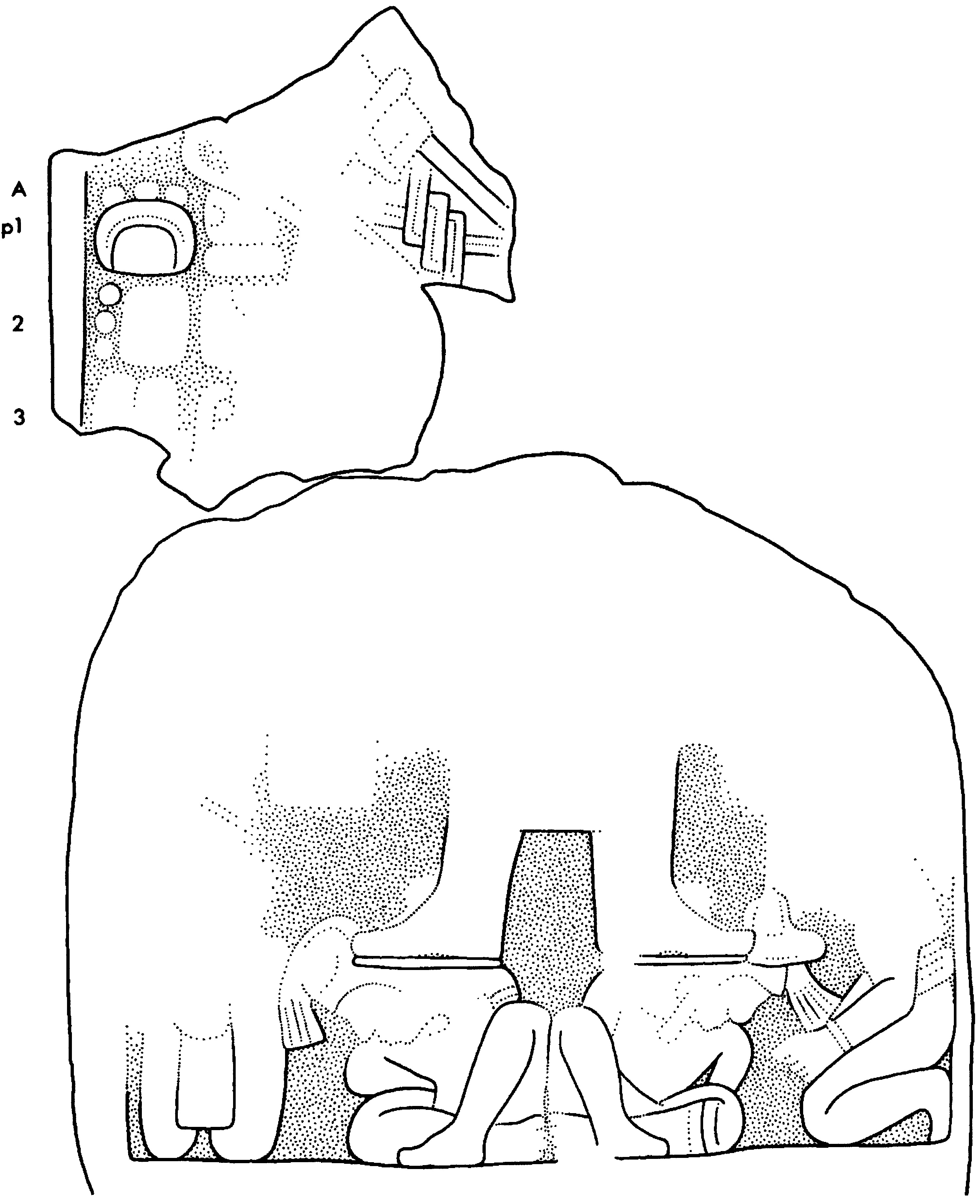
Location
Found in 1929 by Pollock; the lower portion was standing in a shrine just south of the stairway leading to Courts A and B of the Coba Group. There is a difference of forty degrees in orientation between the west-facing stairway and the southwest-facing stela and shrine.
Condition
Shattered. Seven fitting fragments and one other were found by Pollock, and in 1993 others were excavated by Alejandro Mart’nez, including three with preserved sculptural detail. Damage due to weathering ranges from slight to destructive. The actual fit of two of them has not been tried.
Material
Shelly limestone with marked bedding planes; these have caused some of the carved surface to flake off.
Shape
Outline uncertain. Front fairly flat except for right-hand edge behind captive, which recedes. Left side well dressed; back rough.
Dimensions
HLC | 1.49 m plus |
PB | 0.45 m |
MW | 1.38 m |
WBC | 1.36 m |
MTh | 0.29 m |
ReI | 1.4 cm |
Carved Areas
Front only.
Photographs
Lower portion, Pollock; four fragments, Graham.
Drawing
Graham, based on photographs and a field drawing of the lower portion, corrected by artificial light.

Location
Found by Pollock during the Fifth CIW Coba Expedition in 1929.The stela lay broken within a small open shrine centrally placed at the foot of Structure B-16, on its south side.
Condition
Broken into seven principal pieces, with some smaller fragments, one of them never found. Outlines of incised glyphs survive in some areas, but mostly they have been completely obliterated. In ancient times the butt of this stela may have broken from the shaft and subsequently reworked into its present rounded profile.
Material
Limestone; its uneven texture has led to pitting in some areas, flaking in others.
Shape
Tapering slightly from top to bottom, the top having perhaps been flattish. The front is flat, the sides are well dressed. The shaft may never have had much more of a butt than is shown in the photograph.
Dimensions
HLC | 1.71 m |
PB | 0.18 m approx. |
MW | 0.89 m |
WBC | 0.82 m |
MTh | 0.19 m plus |
ReI | 1.2 cm |
Carved Areas
Front only.
Photographs
Pollock.
Drawing
von Euw, based on a field drawing corrected by artificial light.

Location
Found in 1930 by the Sixth CIW Expedition to Coba. The lower part of the stela was in situ on the northeast side of Structure D-45, a small mound about 200 m south of the Pinturas Group.
Condition
Broken into one large and many smaller pieces, but of these the only ones found to preserve any carving are a pair of fitting fragments. Where protected, the carving has remained in good condition; elsewhere it is effaced.
Material
Limestone.
Shape
Unknown. The sides, which have a pronounced taper towards the based, are slightly rounded and well finished. The front surface recedes near the edges. A hole near the middle of the base of carving penetrates almost the entire thickness of the shaft.
Dimensions
HLC | 0.91 m |
PB | unknown |
MW | 1.23 m |
WBC | 1.19 m |
MTh | 0.34 m |
ReI | 2.2 cm |
Carved Areas
Apparently only the front.
Photographs
Standing portion, CIW; fragments, Graham.
Drawing
Graham, that of standing portion based on von Euw's field drawing; that of fragments on his own.

Location
Found by the Sixth CIW Expedition to Coba. It lay between Structure D-16 and the northern terminus of Sacbe 8, apparently not in association with any building.
Condition
Broken into four main fragments, of which two corner pieces are lost. The carved surface is badly eroded, and the lower left corner has been lost since discovery.
Material
Shelly limestone.
Shape
Parallel sides and flat top, perhaps also bottom. The shape suggests that this was not a stela but a lintel.
Dimensions
HLC | 1.49 m |
PB | 0.10 m |
MW | 0.85 m |
WBC | unknown |
MTh | 0.17 m |
ReI | 1.0 cm |
Carved Areas
Front only.
Photographs
Carnegie Institution of Washington.
Drawing
Graham, based on von Euw's field drawing.

Previous Designation
Stela 10 (Morley 1926, p. 275).
Location
Found by the Second CIW Expedition to Coba in 1926; the stela was standing on the south side of Structure C-3, with its sculptured side facing the mound.
Condition
Intact but badly eroded. The shaft has a hole through it in front of the figure's shins and a deep pit behind the figureÕs shoulders.
Material
Limestone.
Shape
The sides may originally have been roughly parallel, and the top is flat. The front is dressed flat, and the right-hand side is fairly well finished, but the opposite side is uneven, perhaps owing to defects in the shaft, while the back is very rough.
Dimensions
HLC | 1.76 m |
PB | unknown |
MW | 0.87 m |
WBC | 0.82 m |
MTh | 0.18 m |
ReI | 2.0 cm |
Carved Areas
Front only.
Photographs
von Euw.
Drawing
von Euw, based on a field drawing corrected by artificial light.

Previous Designation
Morley (1926, p.275) referred to one fragment as Stela 9.
Location
Found in 1926 by the Second CIW Expedition to Coba, at the foot of the main stairway ascending Structure C-1, the Castillo. Its fragments now lie scattered several meters to the southwest of its original locus.
Condition
Broken into many pieces, some retaining clear elements of carving. When recorded by von Euw, the fragments by no means constituted a complete stela, and of these a few could not be found in 1994.
Material
Limestone.
Shape
Uncertain, although the sides may have been parallel and the top flat.
Dimensions
Ht | unknown |
MW | 0.80 approx. |
MTh | 0.25 m approx. |
Rel | 1.1cm |
Carved Areas
Front only.
Photographs
Graham and von Euw.
Drawing
Graham, based on field drawings by von Euw.


Location
Found in 1926 by the Second CIW Expedition to Coba. Most of the shaft lay face up and broken into many pieces at the foot of the subsidiary, or western, stairway of Structure C-1 (the Castillo). Later, INAH workers found the butt in situ, set into the stairway, with is front surface in line with the second row of steps. There it remains, with the fragments lying scattered in the vicinity.
Condition
Broken into five large fragments, plus butt. About one quarter of the text carved in low relief on the butt remains legible; the upper fragments are for the most part severely eroded.
Material
Limestone containing some shells; hard but evidently soluble.
Shape
Sides probably parallel, with a rounded top.
Dimensions
HLC | 2.95 m approx. |
PB EPB | unknown 0.53 approx. |
MW | unknown |
WBC | 1.23 m |
MTh | 0.35 m |
ReI | 2.0 cm |
Carved Areas
Front only.
Photographs
Graham.
Drawing
Graham, based on field drawings by von Euw.


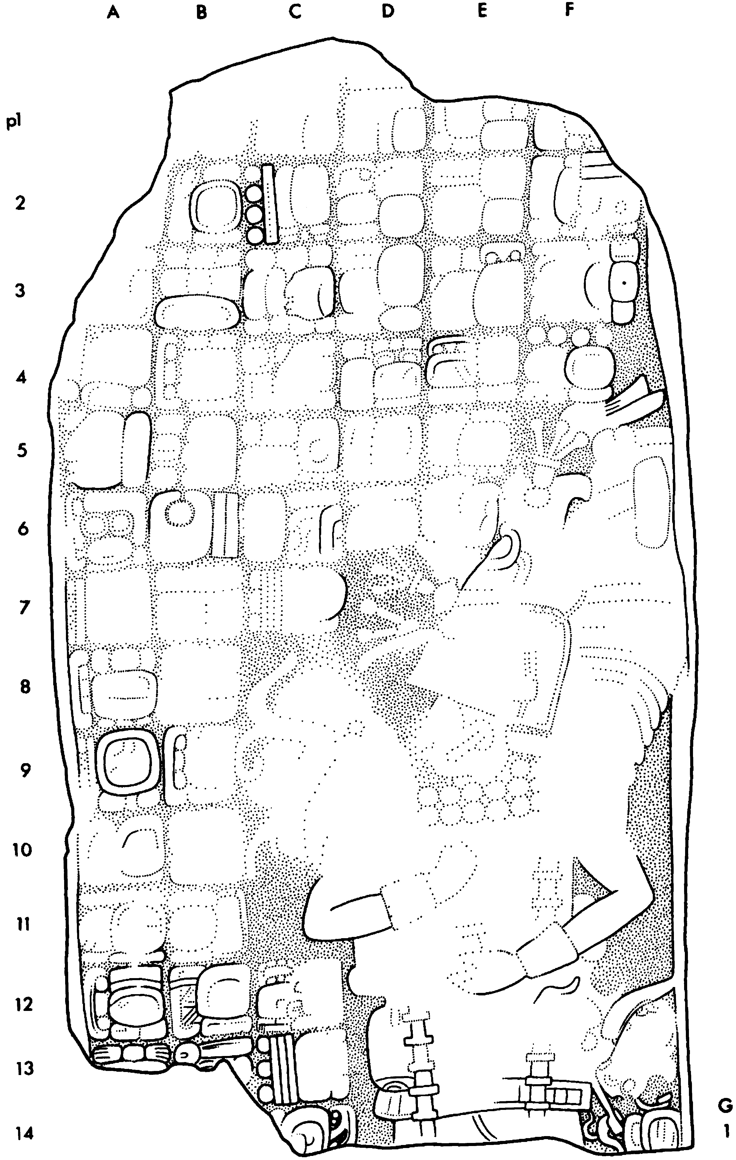
Location
Found in 1930 by the Sixth CIW Expedition to Coba. The stela, originally set into the lower steps of Structure D-1, had fallen on its face, breaking into several pieces; the top fragment, however, was not found until 1974 when Domingo Falc—n, then chief caretaker of the site, discovered it among rubble on the south side of the structure. The stela has been restored and re-erected by INAH.
Condition
Broken into four large pieces. In general the carved surface is well preserved, except for the top.
Material
Limestone with shell inclusions, which are most evident on the badly eroded back.
Shape
Sides parallel and top rounded; sides well dressed, as back may originally have been.
Dimensions
HLC | 3.06 m |
PB | 0.88 m |
MW | 1.19 m |
WBC | 1.19 m |
MTh | 0.28 m |
ReI | 2.2 cm |
Carved Areas
Front only.
Photographs
Graham.
Drawing
von Euw, based on his field drawing corrected by artificial light and on a drawing by George Stuart.


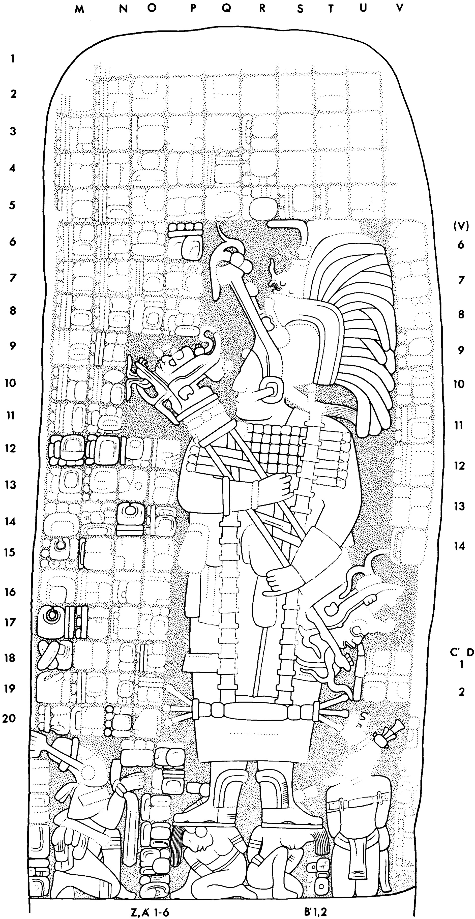
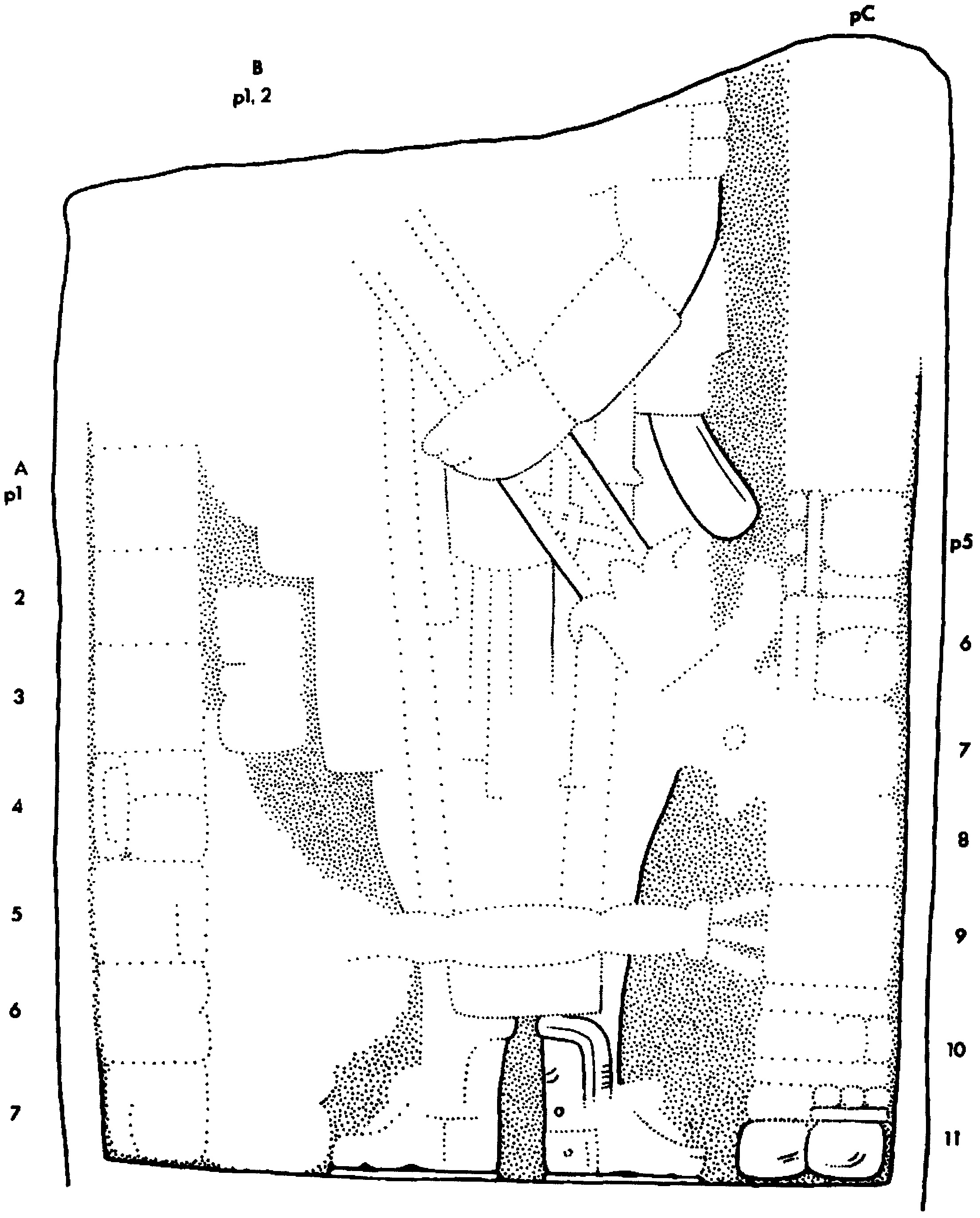
Location
Found in 1930 by the Sixth CIW Expedition to Coba, standing in situ in front of the northeast side of Structure D-2.
Condition
Intact. Erosion of the carved surface grades from extreme at the top to slight at bottom; a portion of the front surface near the left edge has split off.
Material
Limestone.
Shape
The sides were probably parallel before suffering damage; the top is rounded.
Dimensions
HLC | 1.51 m |
PB | unknown |
MW | 0.71 m |
WBC | 0.69 m |
MTh | 0.21 m |
ReI | 1.5 cm |
Carved Areas
Front only.
Photographs
von Euw.
Drawing
von Euw, based on a field drawing corrected by artificial light.

Location
Found in 1930 by the Sixth CIW Expedition to Coba, standing in situ in front of the northeast side of Structure D-2.
Condition
In falling, the stela seems to have fractured across the middle, with both halves later breaking into smaller pieces, many of them now lost. The surface is badly eroded.
Material
Limestone now in very brittle condition.
Shape
The sides were probably parallel before suffering damage; the top is rounded.
Dimensions
HLC | 2.50 m |
PB | 0.84 m |
MW | 1.18 m |
WBC | 1.16 m |
MTh | 0.28 m |
ReI | 2.6 cm |
Carved Areas
Front only.
Photographs
Lower half, Graham; upper half, von Euw.
Drawing
Graham, based on a field drawing by von Euw.

Location
Discovered in 1926 by the Second CIW Expedition to Coba. It was lying face-up at the west corner of Structure C-1, the Castillo.
Condition
Broken into five major pieces. Weathering has destroyed most of the design except the lowermost 25 cm.
Material
Limestone; a shaft probably already flawed by holes when quarried.
Shape
The sides are parallel.
Dimensions
HLC | 1.86 m |
PB | 0.11 m plus |
MW | 1.18 m |
WBC | 1.18 m |
MTh | 0.37 m |
ReI | 1.2 cm |
Carved Areas
Front only.
Photographs
von Euw.
Drawing
von Euw, based on a field drawing corrected by artificial light.